On November 3rd I will be giving s webinar on this topic. Go to the AusIMM website to get your ticket!! (https://www.ausimm.com/conferences-and-events/conferences-and-events-calendar/ ).
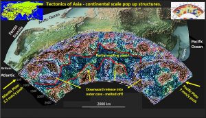
The above figure shows the exaggerated topography of EurAsia and a seismic tomographic section of EurAsia from France to the Pacific Ocean east off Japan.
The Seismic tomographic section is the first structural geology section down the the outer core beneath Asia that I’m aware of. If there are others please show it to me!
Observing the structural geology over such a huge area changes one’s concept of the Earth’s formation.
In the current hypothesis (based on mathematical modeling) there is supposed to be a plastic mobile mantle in the central area from 300 km – 1,500 km depth.
There is no evidence of this earth girdling mobile mantle with brittle structures passing right through this area from the surface to core. The most prominent structural zone is a 500 km wide vertical zone in the centre of Asia that lines up with the large lower topographic area between the Ural mountains and the Central Siberian Plateau to the East. This 3,000 km deep vertical structure has the appearance of the Australian/Pacific plate boundary (Tonga Trench) as seen in Figure 2.
The Africa/Europe collision is shown on the far left and the Pacific Asian Subduction on the far east. It is suggested that most of the excess material produced by this compression is pushed into and melted off by the liquid Outer Core as shown in the bottom right inset of Figure 3.
This seismic tomographic section extends from Sumatra in the West nearly to South America in the East. In the centre are the Solomon Island Plumes.
These have been one of the mainstays of the Mobile Mantle hypothesis of a worldwide convection system which transport the deep hot material upwards at the plumes and associated plate boundaries and downward at the Subduction Zones.
I have no concerns with the subduction zones but the plumes have a major issue. There are brittle structures crossing the plumes that extend from the crust to the mantle. This is impossible if the whole mantle and particularly the plumes are meant to be moving constantly!
My concept, that accounts for the obviously hotter rocks in the ‘plumes’, is that the super-hot fluids from the hotspots on the outer core are ‘insitu’ replacing the lithologies along the breaks on the plate boundaries.
These plate boundaries (Tonga Trench) are seen to go right to the core (another first?) and are not just surface features as currently believed (a structural geology picture tells a thousand words, or a million mathematical modeled numbers).
As I stated at the beginning these are the first structural geology plans that show this whole area and thus some things currently believed sacrosanct may have to be revised.
The diagram is fairly self explanatory. Along the top from left to right is a series of images that explain the currently popular Earth Evolution process. It is based largely on mathematical modeling of geophysical measurements under the earth. This is indirect evidence.
Along the bottom is my hypothesis based on observation of actual structural geology.
The current hypothesis;
That the earth is hit by Gaia (left top inset), a Mars sized planet and both part of Earth and Gaia explode and form a molten magma around the earth which after 200 million years coalesces into our current Earth and the moon (centre top insets).
The Earth is hot and has only a thin crust which is still gradually accreting into continents. None of the impact structures from the Late Heavy Bombardment (LHB), which probably ran from 4.5 Ga to 3.6 Ga, are remaining having been recycled by the relentless conveyor belt of the mobile mantle plumes and subduction. The excess material is mainly recycled back to the surface through the plate boundaries (the Mid Atlantic Ridge is one valid example).
Thus, the solid crust is still only a thin 20 – 100 km thick shell over the mobile mantle (far right inset).
Watchorn Hypothesis;
The original Earth was not as hot as believed.
When Gaia hit then the huge cloud of particles would enter the -100 C space temperature and cool right down before gradually coalescing over the next 200 million years. There is still a huge ‘impact’ area with a huge hotspot under the central pacific which is where most of the upwelling magma still comes from. This is suggested to be where Gaia hit.
The image of earthquake epicentres around the Pacific (far left bottom inset) show this clearly.
Earth almost from outset was cool enough to have an ocean covered surface (evidence from the oldest Earth rocks and zircons). This ocean remained throughout the LHB and through to today. NOT HOT.
The Earth was essentially rigid and brittle right throughout its evolution. The ring structures and impact bowls from the LHB can be observed in all seismic tomographic sections down to over 1,000 km depth.
However, tectonics similar to plate tectonics can occur by brittle movement (similar to a glacier) and this is what the EagleEye enhanced seismic tomographic section around the world show. It is suggested that most of the excess material produced by this compression is pushed into and melted off by the liquid Outer Core as shown in the bottom right of Figure 3. The rest is eroded away from the top.
If you want a detailed expose of the above topic visit the AusIMM website and register for the Webinar. https://www.ausimm.com/conferences-and-events/conferences-and-events-calendar/
Cheers
Bob
