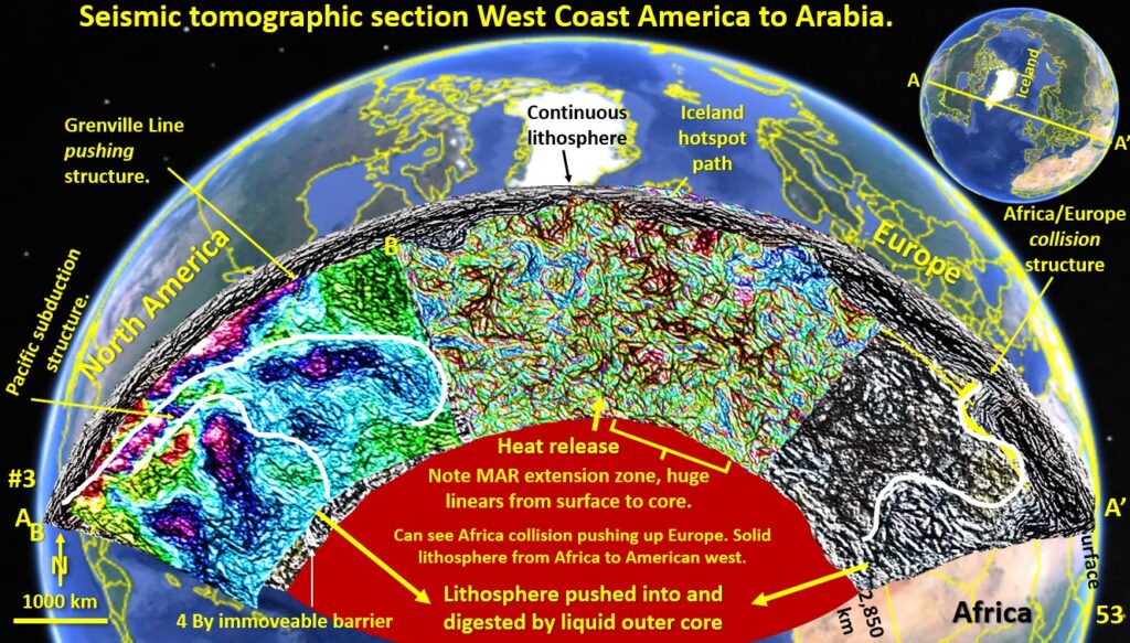
Figure 53. Seismic tomography section through North America, Greenland, Europe to Arabian Peninsular From the crust to the Outer Core.
This figure is a section from the Pacific Ocean off California, through Hudson Bay, Greenland, Iceland, through central Europe, Israel and finishing in the Arabian Peninsula. This figure first appeared in the Webinar on North America. Different details are available there. https://www.ausimm.com/videos/community-event/south-west-wageoscience-society—digital-tech-talk-new-discoveries-in-the-structural-geology-mineralization–exploration-targeting-of-north-america/ Enlarge the Figure to see the detail.
Crust.
The first thing to notice is the crust, which is the dark grey laminated zone from 0 to 100 km deep. This is clearly visible, but not at all visible in the original colour contour section. This shows the power of EagleEye structural definition.
African/Europe collision zone and the French Alp’s nappe structure.
The collision zone is clearly seen (white wavy line on right-side) and does not appear to extend to the core.
The Alpine collision nappe structure is observed (yellow arc) on the right-side of the section. Once again, this level of detail is not seen on any regional seismic tomographic section in any other publication that I have accessed.
Grenville Line pushing structure.
This well documented structure can be seen as a thickening of the crust East of Greenland and correlates with the east coast of North America. Once again, I have not seen this on any other section.
Pacific Plate subduction zone.
The large blue and yellow area (white outline) on the left-side is the Pacific plate subduction zone under North America.
It is very shallow under North America which suggests a huge time period for its eroding off the underside of North America and its accumulation.
It is very similar in shape but more elongated than the South American subduction zone (figure 47 part 13) but in both cases the blue, cooler subducted material (2,400°C) is pushed right down into the 4,500°C – 5,500°C Outer Core where it is cleanly cut off and incorporated into the liquid Outer Core, pressurising it and forcing superheated material back up any weakness to the surface. In this case the closest weakness is the Mid Atlantic Ridge.
Mineralisation pathways under North America.
Strong, sub-vertical fault-lines extend from the outer core to the base of the crust of the North American continent through this subduction zone. These are similar to those seen in South America (figure 47 part 13) and once again they line up with the strong mineralised areas in North America as seen in the webinar on North America.
Mid Atlantic Ridge.
This seismic tomographic section clarifies the often-debated question of what does the mid-Atlantic Ridge look like and how deep does it penetrate. I have not seen a structural geology section of the Mid Atlantic Ridge in the published literature, hence the debate! This debate can now be based on real evidence!
In the centre of the section under Iceland/Greenland is the Mid Atlantic Ridge. On the west-side of the mid-Atlantic Ridge under Greenland there is a very strong structure going right from the surface to the core, outlined by a black arrow top, and yellow arrow bottom.
On the East-side east of Iceland there is a series of steep east-dipping structures extending from the surface to the core, but are strongest down to 1,500 kms.
The Mid Atlantic Ridge central area structures consist of a crosshatch of mainly vertical and horizontal structures. These are the type of structures one would expect from a steeply faulted zone getting differentially pushed apart, at different levels and latitudes, by material coming up from the overpressurised Outer Core.
These Mid Atlantic Ridge structures under Iceland extend down to about the 1,500 km depth mark and then are less obvious beneath this level. The strongest structures mainly occur between the two strong, sub-vertical structures as previously mentioned.
So, the Mid Atlantic Ridge plate boundary extends steeply right from the core to the surface.
This is in agreement with the Pacific/Australian and Pacific/Nazca plate boundaries already examined.
Conclusion.
I would be very interested to see if a detailed structural geology cross-section like my EagleEye section can be found in the published literature? Any takers?

