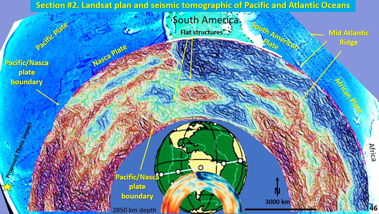
Figure 46. Landsat Plan and seismic tomography section of Pacific Ocean South America and Atlantic Ocean.
This seismic section extends from the Tonga Trench (yellow star, proposed Theia impact site) through South America, across the Atlantic Ocean and Mid Atlantic Ridge to the West Coast of Africa.
We will now focus on the Pacific/Nasca plate boundary and the subduction zone under South America. We will examine the Mid Atlantic Ridge up at the Iceland type section later.
Pacific/Nasca plate boundary.
There is a strong sub-vertical boundary between the Pacific and the Nasca plate which appears to step eastward as it descends. To the west of this plate boundary is where the biggest heat source on Earth emanates from the Outer Core into the Lithosphere (Theia Impact?).
Subduction zone under South
America.
A closer examination of the eastern Pacific Ocean and subduction zone under South America reveals that, even at this broad scale, strong flat structures cut across the lithosphere.
Are these structures artefacts of the EagleEye process or are they real?
Will now be looking closer at the subduction zone under South America to ascertain if the structural geology correlates between this broad scale and a closer scale.

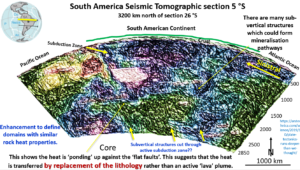
This figure shows the subduction zone under the wide area of South America at 5°S.
The upper yellow arrows show the top of the subduction zone which is quite clearly defined. This is subducting cool brittle oceanic crust (blue colour),which is pushed by the Nasca Plate right down to the outer core where it is cut off by the liquid Outer Core. There are huge volumes of oceanic and continental crust adding to the Outer Core. It is suggested that the method of movement of this brittle material is similar to the way a glacier moves.
The rest of the lower lithosphere is brownish and quite hot (or wet) by comparison.
An important geological feature to note in this section, that relates to the brittleness or ductility of the lithosphere, is the sharp boundary between the brown and blue rocks extending from under the Atlantic Ocean on the right- hand side, to nearly down to the Outer Core on the left-hand side.
Flat fault system?
I suggest that this is a big flat fault system, no doubt caused by the inexorable movement of the Nasca Plate to the east and the pushing westward of South America by the Mid Atlantic Ridge opening. The whole American continent is thus sitting on flat East dipping, and flat West dipping pressure-relief faults and is a pop-up continent.
This sharp boundary, of the brown rock against the blue rock, suggests the method by which the heat and material is rising from the Outer Core to the surface. The area under South America has the same flat and vertical structures right down to the outer core across both the brown and the blue lithosphere without much difference in the morphology of the structures as they cross each colour. This structural geology suggests that the hotter brown material is insitu heat volume/volume replacement of pre-existing cooler blue lithosphere and not a viscous plume as it is currently hypothesised.
Note that the strongest wavy, vertical structures terminate under South America right where the mines are located.
These strong some vertical wavy structures are transgressing the subduction zone with only minor lateral movement suggests that they are constantly active and that the slow-moving subduction zone does not break these structures enough (or stopping them reforming) and thus the fluids rising almost vertically from the core to the surface over time.
I believe this is one of the primary mineralising mechanisms on Earth and is a huge advance in our global understanding of fluid flow. There will be more on this concept in my global mineralising systems Webinar on May 23rd.

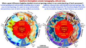
This summary figure shows all the seismic tomography cross-sections that we studied around the southern hemisphere.
The left-hand figure shows the current colour contoured view of the seismic tomography sections and is how they are normally presented. These plans are the only ones available to be studied, thus, one could easily believe that the central area is ductile and the orange and red areas are hot plumes rising from the core to the surface as there is no hard detail to argue otherwise!
However, the EagleEye seismic tomography sections shows a huge increase in hard structural geological detail which totally changes the paradigms of Earth’s Evolution.
The plate boundaries, (Tonga trench and the Nasca plate) extend sub-vertically from the surface to the outer core. Vertical structures through the mobile mantle?? This is not possible!!
The Tonga hot-spots (10 o’clock) and the large vertical hot area under Africa (5 o’clock) which we saw earlier, are currently called plumes but because of numerous hard geological structures cutting them are definitely not viscous moving plumes!

