

In this section we will discuss the correlation of the henges with the ancient mines in the British Isles and how the Great Orme mine illustrates the great importance Copper mining played in the formation of European trading routes.

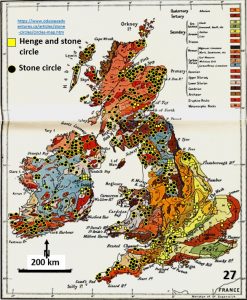
This is a geology plan of Great Britain and Ireland onto which I have overlaid the stone rings and henges.
The henges do not follow the geological boundaries showing on this plan.
So, if the linear and arcuate arrangement of henges don’t follow surface geology what do they follow? They definitely don’t follow the best agricultural land!
The commencement of agriculture is usually given as the reason for the formation of civilisation. This seems not to be the case on the British Isles!

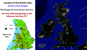
This plan shows the henges in Great Britain and Ireland and shows them following linears and large arcs from one end of the islands to the other.
In earlier figures we showed that the henges and mines were spatially related across Europe.
The Ley Line plan shows in better detail how their alignment was recognised 300 – 400 years ago. These Ley Lines were ascribed all sorts of mystical qualities. However, as can be seen on the right hand plan, they are very real! Perhaps the Ley Lines have a more geological explanation?
If we can show that these henges correlate with the mines in a more local sense (British Isles) then we are perhaps showing what catalysed advanced civilisation.

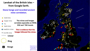
This plan shows the ancient mines plotted on the same plan as the henges. The mines follow the same NNW and ENE trends that the henges follow. The best mines are associated with the biggest henges.
What causes the linear and arcuate arrangement of the henges? We will look at that aspect in the next post.
****Very important note ****
One mine on this plan is the Great Orme mine in Northern Wales (red dot in lower centre of plan). The Great Orme mine illustrates the great importance that one rich mine had on the development of trade routes and civilisation in Europe. The ore was rich in nickel and arsenic and thus could be isotopically fingerprinted.
Note from – https://archaeology.co.uk/articles/news/great-ormes-golden-age-of-european-trade.htm states –
……. using the isotopic method, scientists were able to see that metal from the mine dominated Britain’s supply for up to 200 years (c.1600-1400 BC), with some metal being traded in the form of palstave axes into continental Europe, stretching across northern France, the Netherlands, and as far as Sweden.
This extraordinary 200-year copper boom of high production at the Great Orme mine suggests that Britain was much more integrated into European Bronze Age trade and exchange networks than had previously been thought, given that Britain was a region of scattered farming communities.
This mine was so rich that it sent many of the copper mines in Europe bankrupt when it was mined. Even though it is only a small mine it would be like finding a new Kalgoorlie or Broken Hill back in BCE times.
This mine also shows how intensively copper was traded throughout history. The copper out of the Great Orme mine in Wales affected the whole European copper production and trade routes.
Once again i make the point that trading of farming products would not have spurred the earliest trade routes of the ancient world like the trading of high value metals.
Cheers and happy trading!
Bob Watchorn