YW #3. Leonora Ring Structural Geology Research using Landsat, magnetics and gravity data images. An Enigma being resolved?
© Robert Bingley Watchorn 9th July 2017
Introducton
The aim of these papers on giant ring structures (GRS) is to provide an earthscale focus on the underlying architecture of the Yilgarn – and beyond. There are many unresolved questions in all of the Archaean Cratons. The following quote from MaCuaig et al 2010 parallels my research objectives. The fact that none of these giant ring structures have been recorded or researched is instructive and is an obvious flaw in the research to date. It will be seen, as the papers accumulate, that they answer some of the HOW and WHEN of the following research questions.
Summary of recent academic research (from Controls on Giant mineral systems in the Yilgarn, McCuaig et al 2010)
Advances in the past decade have clarified the tectonic history of the Yilgarn Province, and in particular the Eastern Goldfields Superterrane. Key developments have been:
1) the recognition of large scale lithospheric architecture reactivated through time;
2) the control of this architecture on the distribution and preservation of supracrustal sequences;
3) clarification of the intrusive and metamorphic histories of the region;
4) the integration of these multiple geoscience disciplines to resolve the tectonic history of the region.
Structural evaluation of the Leonora ring.
Leonora ring interesting observations.
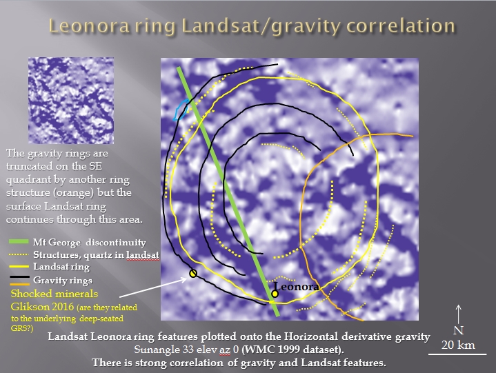
The Leonora GRS cuts through the Mt George discontinuity without disruption and yet the Mt George discontinuity is not apparently disrupted by the ring? The ring may also be the conduit for the gold mineralisation which has varying ages.
How can these disparate facts relate? It is suggested that the Leonora ring, which is the median ring of the Watchorn GRS, is a much earlier structure that is reactivated right through geological time as explained in a previous paper (Watchorn,YW #2 2017).
The Leonora ring is almost perfectly circular and has been evaluated on Landsat (Watchorn YW #1 and YW #2 2017). Another question to be answered is how can the GRSs be so circular (and strong) when they appear to cut across presumably younger surface geological structure that is so deformed? Is the late deformation (post 3Ga) only near the surface? Is it caused by massive intrusions and extrusions through a rigid lower crust? Was it a similar process to the Hawaiian hotspot today?
Leonora ring Landsat and gravity superimposed on the TMI (Whitaker GA 1377, 1500m TMI, 2004). The Landsat ring structures (yellow) correlate with the gravity ring structures (black).
It is suggested that the area within the Leonora ring is the centre of a buried Watchorn impact structure (Watchorn 2013) and the gravity signature is caused by multiple intrusions at depth – only some of which reach the surface. These differentiated intrusions, being lighter than the greenstone belt, would cause ongoing isostatic adjustment which may be the cause of the continuing Leonora ring uplift (Watchorn YW #2, 2017) resulting in the Landsat ring being the same size and located directly above the gravity rings . This will be covered more definitively in a future paper dealing with the relationship of the surface rings with surface structures and features seen in the 01 AGS NY 1 Seismic Traverse which traverses the rings …………….
To read more ……
| YW 3 Leonora ring structural study | 2.4 MB |

