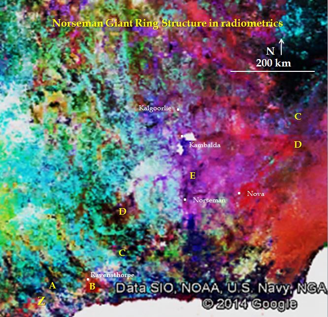
YN #1. Norseman, an unreported 700 km diameter giant ring structure defined by radiometrics. Real or imaginary? Impact structure or superplume? Is a revision of Yilgarn Craton geology and exploration fundamentals required.
Yilgarn Craton enhanced radiometrics with interpreted Norseman giant ring structure
Introduction. The Norseman area has always had a fascination for me as a geologist. I worked there from 1976 – 1980 and at odd times through to 2013 when I had 5 months with the current owners putting back together the resources and exploration targets.
The aim of these papers on giant ring structures (GRS) is to provide an earthscale focus on the underlying architecture of the Yilgarn Craton. There are many unresolved questions in all of the Archaean Cratons.
Norseman is the SE most goldfield (10Moz) in the Yilgarn Craton and has high grade gold mines and a huge volume of low grade (0.4%) nickel mineralisation both on the Jimberlana Proterozoic dyke and in the equivalent of the Kambalda Komatiites. There are also small deposits of tin, scheelite, rare earths, tantalum and uranium. Although it is in the Fraser Orogen, the Nova nickel mine lies within the area of the GRS. The nearer surface local controls on the mineralisation are relatively well known but, like all of the Yilgarn Craton mineralisation, the fundamental Craton architecture and basement controls are poorly known. The fact that none of these giant ring structures have been recorded or researched is an obvious flaw in the research to date.
The Norseman GRS is centred at approximately S 32° 09′ E 121°13′. The inner ring is 200km diameter and there are rings and ovoids out to 700km diameter, not including the section of rings that disappear under the Cretaceous Nullarbor limestones. The rings show up on radiometrics as darker (less radioactive) bands about 15km in width and continue across all underlying geology as if they are very recent, post Fraser Orogen (1.2Ga) and pre-Cretaceous.
Is this correct …read more in the paper…
Mineralisation control?
Arcs C, D pass through the elephant Kalgoorlie/Kambalda mining camps and arc Z passes through the giant Laverton/Wallaby/Sunrise Dam camp and the large Leonora camp. This is, I suggest, a bit more than coincidence. All of these camps have been researched and the ore in every case occurs above deep-seated, stacked domes in the geology (Blewett and Hitchman 2006 p 245-252). The influence of very visible, deep-seated EW structures (arcs C, D and Z) may be responsible for the doming of the NNW trending lithologies and structural plumbing associated with the largest gold mines. Did this cause the giant ore camp forming environment?
To read more click below…..
| YN #1 Norseman GRS in radiometrics | 5.2 MB |

