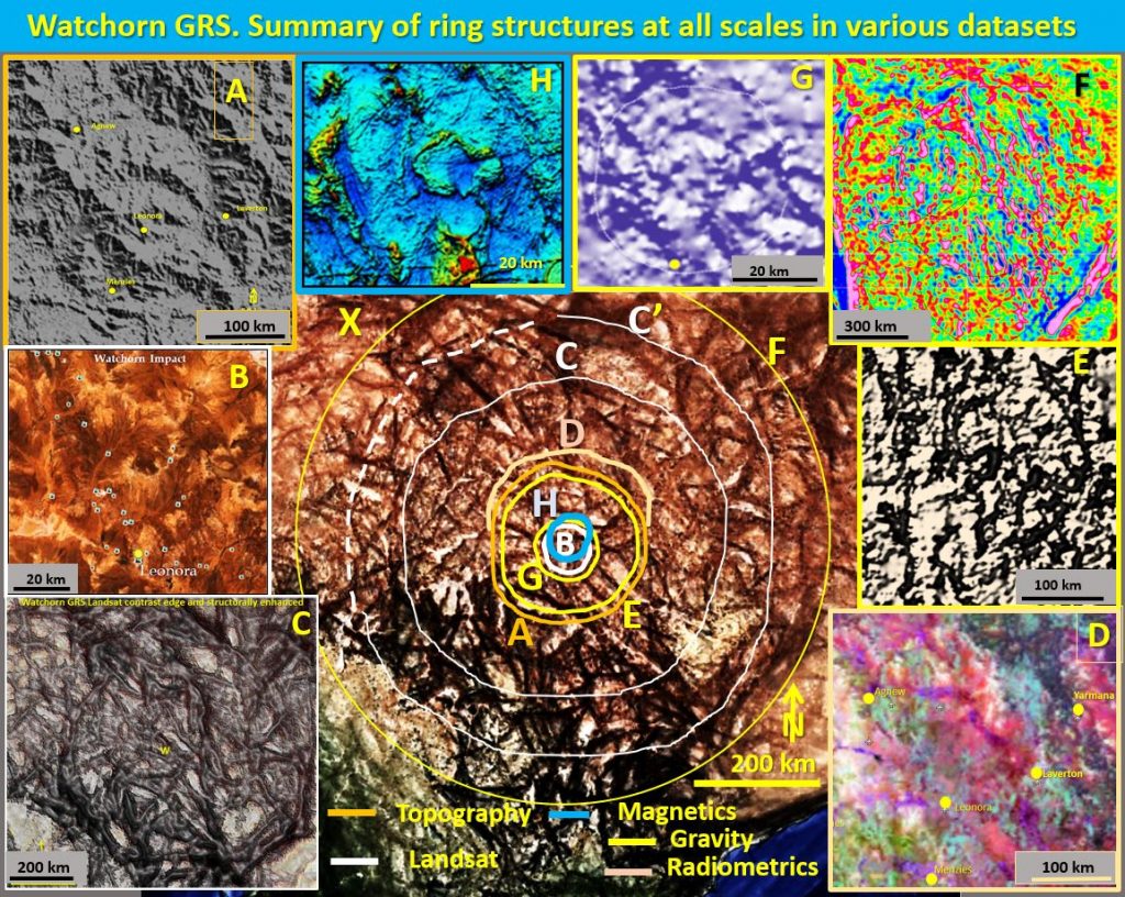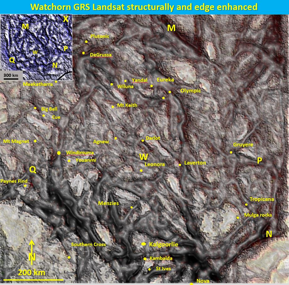
Watchorn giant ring structure showing data insets A – H and interpreted central Landsat inset X. Watchorn GRS has the morphology of a giant impact structure.
Watchorn giant ring structure (GRS) location.
Watchorn giant ring structure is centered 40 kilometres NNE of Leonora, at longitude 121°25¢ and latitude 28°25°S. The bones deep beneath the thin skin of the surface crust of this GRS are being revealed.
Watchorn giant ring structure, dimensions and genesis (inset X in above figure).
The rings have the morphometric dimensions of a 1000 km diameter impact structure. Theset are observed in Landsat, topographic, gravity, magnetics, radiometric, seismic and seismic tomographic data. The ring structures observed correlate in all datasets over all scales even down to 250 km depth in seismic tomography. They are however generally unrelated to the surface geology.
Veracity of the rings. Statistical examination (Lambert Email 25th August 2018 and Lambert 2018, https://eurogeologists.eu/lambert-the-hunt-for-phi-structures/ ) of the rings in insets A and F proves conclusively that the rings are real and not just local geological or non-geological artifacts or derived from human induced bias.
Watchorn giant ring structure comparison with Lunar Mares and Australasian plate seismic tomography. The more closely the images are examined the more overlapping rings are seen. This can be confusing. However, if the rings are the surface expression of an Earth equivalent of the Lunar mares formed by the Late Heavy Bombardment this overlapping, multiplicity of rings is exactly what should be observed. There is a strong correlation between the Lunar mares and Earth Archaean/Proterozoic cratons, with overlapping multiple rings – like the overlapping ring pattern formed by raindrops on water. This will only occur with large complex craters that penetrate through to the plastic asthenosphere. This suggests an impact origin the Yilgarn Craton and of Watchorn (and other) giant ring structures. There is a giant ring structure in the structurally enhanced seismic tomography data at 250 km depth that correlates with Watchorn GRS suggesting a common impact genesis.
Watchorn giant ring structure correlation with major gold mines (inset X). The major gold mining districts show strong correlation with the interior of the rings as well as the junction of NNW and NE structures with the rings. The Wiluna – Kalgoorlie Ring C is associated with (among others) the Kambalda, Kalgoorlie, Windimurra, Youanmi, Gabanintha, Wiluna, Eureka, Olympic and Gruyere mines and projects.
The Meekatharra – Tropicana Outer gravity ring F is associated with (among others) the Mt Magnet, Cue, Big Bell, Meekatharra, DeGrussa, Tropicana, Mulga Rocks, Nova, Norseman and Southern Cross mines and projects. It is stronger (darker) in the east and weaker and more discontinuous in the west. These rings correlate strongly with the gravity rings.
Watchorn giant ring structure correlation with topography – Inset A in above figure. The topography of the 250 km diameter Agnew ring was analysed by Andre Lambert using the neural net routine and is clearly observed. An offset ring partially correlates with the Leonora ring. Andre Lambert has been researching worldwide phi structures which are ring structures cut by linear structures (Lambert 2018 https://eurogeologists.eu/lambert-the-hunt-for-phi-structures/ ).
Andre Lambert produced the above figure using the neural network routine. He did the probability statistics on the 250 km diameter Agnew ring in topography and it is a bona fide ring structure. There is only a 4% probability that it is not a naturally occurring giant ring – phi structure.
Watchorn giant ring structure correlation with Landsat of the median Leonora ring (inset B in above figure)
The Leonora giant ring structure cuts off and overprints the large arcuate palaeochannels. This was caused by small elevation differences (4 – 10m) across the Leonora ring structure. This elevation difference was quantified by measurement on Google Earth. This suggests that the core of the Leonora ring has popped up and is still rising. This central uplift is one of the main criteria of the centre of an impact structure.
Watchorn giant ring structure correlation with prima facies evidence in ELV 071 (inset B). Prima facies evidence suggesting Watchorn GRS is an impact structure is seen in ELV 071 diamond drillhole core which was drilled into the strong Leonora ring.
Glikson, Hickman and Crossley, in 2016 described the core containing these planar deformation features as a post Permian shocked deformation breccia indicative of a nearby impact. The core however is unequivocally Archaean. The only known, documented local source for this Archaean shock deformation breccia is the Watchorn giant ring structure’s Leonora ring.
The Watchorn giant ring structure has all of the attributes of an impact structure which fits with these proved associated shock deformation rocks. Watchorn giant ring structure is huge and strong enough to produce shock deformation minerals 50 km from the centre.
Watchorn giant ring structure correlation in Landsat data with the 650 Km diameter Wiluna ring and the surface geology (inset X and C).
There is a good correlation of the structures observed on these enhanced Landsat images with a few of the published large scale geological structures in the Yilgarn Craton.
The NNW zone to the west of Kalgoorlie correlates with the Youanmi/Kalgoorlie terrane boundary (Ida fault).
The N – NNW zone from east of Kalgoorlie through Olympic project correlates with the Kurnalpi/Burtville terrane boundary.
The WNW linears are part of the well-recognised Shark Bay/Eucla linear system.
The NE linears are documented at all mining districts but especially at Mt Magnet, Big Bell Meekatharra, Kalgoorlie, Kambalda/St Ives and Norseman. There is also good correlation of the rings with large zones of steep, shocked appearance structures in seismic sections 10 GA YU 02 and 01 AGS NY 01 that cross the Watchorn GRS.
Watchorn giant ring structure correlation with seismic cross sections. Seismic cross section evidence shows that the strong steep structures associated with the ring structures terminate 5-15 km beneath the current surface. They show that the main impact structure doesn’t outcrop but that the ring structures seen at the surface are caused by very strong post-impact re-activation (by isostasy and subsequent crust movements) of these deep structures breaking through to the surface.
Watchorn GRS ring correlation with radiometrics (inset D). The ring structures are observed in the radiometric signature of the Yilgarn. The reason for using K/Th/U Radiometrics for examining for evidence of ring structures is because radiometrics reflects changes in lithologies. Mineral content is most likely associated with later intrusive rocks following shear/fracture zones up the extension to the surface of the deep-seated ring structures.
In radiometrics the centre of Watchorn GRS is observed as a lighter red/pink circular area within the redder potassium rich Eastern Goldfields Superterrane. There is a well-defined radiometric ring segment from Agnew around to Laverton which is less well defined from Laverton, Menzies, Mt Ida and back to Agnew. The central Leonora ring is the deepest red showing higher potassium enrichment.
Gold districts are known to have elevated potassium from K metasomatism. K metasomatism probably came from deep in the earth to give time and distance for complete fractionation.
Watchorn giant ring structure correlation with gravity (insets E, F and G). The gravity rings correlate with the Landsat and radiometrics but not with the surface geology of the area. This correlation suggests that the rings have different underlying geological characteristics than those mapped at the surface. This gravity signature is probably caused by multiple intrusions at depth – only some of which reach the surface.
Watchorn giant ring structure non-correlation with underlying Yilgarn geology (inset F). The satellite gravity image of the southern half of Western Australia shows in more detail the multiple overlapping rings seen in the seismic tomographic image of Australia (inset X). These rings are 100 – 1000 km diameter. Rings of higher gravity enclose central areas of lower gravity. This is a characteristic of large complex impact structures.
The underlying structural fabric of the Yilgarn extends >400 km east of Gruyere and a similar distance to the north of Wiluna in the North Yilgarn. The outer rings traverse these areas and underlie part of the Officer Basin and the Fraser Orogen to the east and the Yerrida and Earaheedy basins to the north. The probability that Watchorn GRS (in the image generated by the Hough Routine in inset F) is a bona fide ring structure was calculated by Lambert at 96%.
Watchorn giant ring structure correlation with magnetics Inset H).
The magnetics, gravity and Landsat of the larger 80 km diameter Leonora ring, the centre of the Watchorn ring structure, show a correlation of greenstone belt cut-offs, sharp dextral bends and dextral arcuate disruptions.
The magnetics of a 40 km diameter inner ring (blue top right inset in Inset H) has a central magnetic high and lower, smoother magnetic intensity than the surrounding area. Large impacts exhibit shock-induced demagnetization, homogenization and reduction of the remnant induced magnetic components of originally complex terrain. The magnetics centre of the Leonora ring has these characteristics and in 2004 it was suggested that the Leonora magnetic anomaly at the centre of the Watchorn GRS was evidence of the impact structure at the surface. A paper was co-written with Andrew Glikson in 2004 for the AJES. However, field trips discovered no evidence of shock deformation structures and so, though lack of surface evidence, the paper was not carried through to publication.
It is now suggested that an older, buried impact structure may have caused demagnetisation at depth which is still evident through the thin (5-10 km) overlying greenstone belts and granites at the current surface. The centre of the impact structure would have experienced the greatest uplift bringing the demagnetised underlying rocks closer to the surface.
Summary. The Watchorn giant ring structure has the morphometric dimensions, in many datasets, of a 1,000 km diameter complex impact structure. The ring structures in the topography and in satellite gravity have been verified as real in the data with only a 4% probability that they are random artifacts. Prima facies evidence in the form of shocked breccia xenoliths in a mafic pipe that lies on the strong Leonora median ring also indicate an impact origin. All the researched evidence points to Watchorn GRS being an impact structure.
A detailed paper on the probable impact origin of Watchorn giant ring structure can be accessed at —-
| aa YW #7 Watchorn GRS plan evidence (0-50km depth) of impact origin..pdf | 1 MB |
Share this paper with your colleagues and follow the unfolding research.

