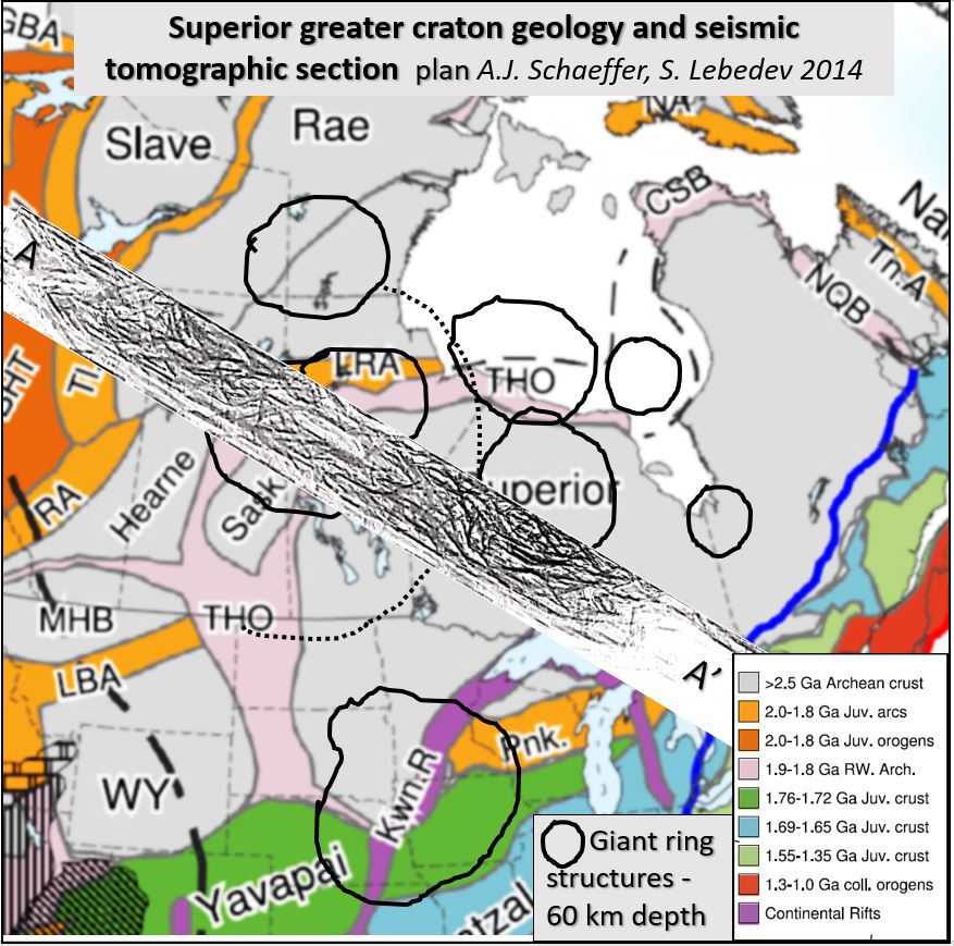
Superior Craton seismic tomography research at 60 km depth and WNW-ESE orthogonal section from Alaska to Lake Ontario and its correlation with Abitibi belt mineralisation.
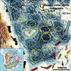
Superior Craton seismic tomography. This structurally enhanced tomographic image of Canada at ~60 km depth shows giant ring structures which have the morphology of impacts (yellow circles). The underlying cratonic Lithosphere extends unbroken from Alaska to the Southern United States of Texas and Louisiana.
Superior Craton seismic tomography.
This paper the first of a series of papers to describe the genesis and mineralisation of the North American Superior Greater Craton from the 60 to 300 km depth using detailed seismic tomography. Greater Superior Craton occupies the core of the North American continent.
What is new about this Superior Craton seismic tomography
research?
A search of seismic tomography publications in Canada suggests that current research only defines structures of > 50 – 100 km size. High resolution structural seismic tomography (5-10 km wide dimensions) has not been yet used to determine Canada’s detailed deep geological structure. My research is defining structures to < 5 km width.
Superior Craton seismic tomography data used.
This paper explores the craton in plan at ~60 km depth and the WNW-ESE orthogonal section from Alaska to Lake Ontario using detailed seismic tomography. A brief study of the relationship of the Abitibi mineral belt to the craton is also included.
Superior craton genesis.
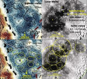
This Archaean (most probably Hadean >3.8 Ga) impact zone encompasses an area of 5000 km NS and 2000 km EW. It is about 2 times the area of the Lunar mares.
Relationship of the Superior craton giant ring structures in plan and section.
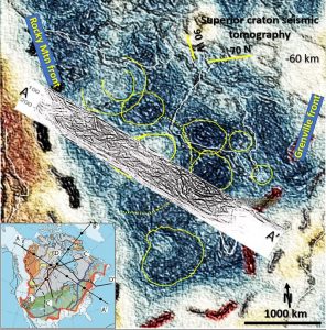
The WNW section shows large bowl like arcs down to 250 km (yellow). These correlate with the giant ring (impact) structures in plan especially in the ESE where the centre of a probable impact centre is close to the section line.
Superior craton interpretation on plan and section and relationship to the Abitibi mining belt.
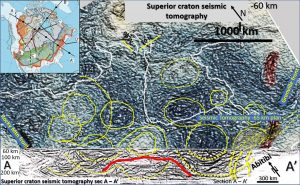
There are large upward facing semicircular arcs under what appears to be an uplifted central zone (red). Above this central area is a lighter coloured bowl like area which is restricted to the surface. This may be the result of younger rock deposited in the original bowl of the largest central core impact which correlates with the Saskatchewan craton.
The western half of the craton appears to have the bottom half insitu-volume for volume replaced by the mantle as the structures are still present but are less clear.
The shear zones or breaks of the Abitibi belt of mineralisation in the lower right (gold mines – yellow, nickel – black, enlarge to 300% to see) correlate well with steep structures on section which most likely are the mineralisation pathways. These pathways are almost identical to those observed on section beneath the Kalgoorlie – Wiluna mineralised belt in the Yilgarn Craton, Western Australia.
There is almost no correlation between the surface geological data and the -60 km depth giant ring structures. This suggests, as does cross-section A-A’, that the ring structures terminate below the crust and only indirectly affect the crustal surface geology as Trans-Lithospherical structures. All of the surface geology post-dates the giant ring structures.
This strongly suggests the Greater Superior Craton crust formed over this craton-wide lithosphere and not as a series of accretionary, or rifting, events. The largest, latest structures are still circular. If accretion had occurred then the Late Heavy Bombardment giant ring structures would be segmented, distorted and broken up.
Giant ring structures in gravity data associated with Abitibi mining belt.
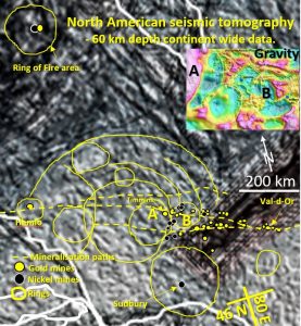
In 2009 I observed giant ring structures on the Abitibi belt in gravity data (inset). Rings A and B are located in the same position in the seismic tomography and in the gravity inset. There is a faint ring structure around Sudbury that matches the known 200 km impact structure. The Sudbury impact ring structure is circular at -65 km depth and squashed from the south into an ovoid at the surface. This suggests later (post 2 Ga) surface tectonic movement which doesn’t penetrate to the Lithosphere.
These structures will be seen more clearly with the better data in the next few papers. The Abitibi, Hemlo and ring of fire mineral district surface structures correlate well with the structures on the -60 km depth. This may mean the mineralising structures are vertical.
Superior craton Abitibi belt mineralising pathway to -250 km depth.
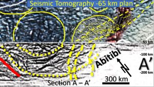
The giant ring structures and probable mineralising pathways are interpreted. This is very much a first foray into Canadian mineralisation control. Gold appears to be located on the EW shear zones and the nickel mines on the NNE fractures and the rings. The best mines (especially the nickel mines) lie at the intersections of the rings and the linear structures.
The difference between this and past Superior craton research.
Geoscientists have researched extensively to discern the Superior craton controlling structures; with some near-surface local success but the overall Cratonic control has not been discovered. Have we been examining them too locally? It is only when the structures are viewed at a broad scale, as a complete structural set, that their pattern and genesis becomes clearer. The Superior cratonic structures are starting to be outlined in 3D using this new detailed tomography.
These detailed plans open up a whole new world of structural research to those exploring the structural geology and mineralisation of North America. Of great interest will be the research into the controlling tectonic systems and their relationship to mineralisation to the 3D structure of Canada. The above is very much a first pass.
Superior craton future research.
Future research will examine the Superior Greater craton at the -100, 150, 200, 250, 300 and 350 km levels. Other cross-sections will also be examined.
Comparison with the Lunar mares, Venusian plateaux and the Superior super-craton’s geochronology, genesis and mineralisation will also be examined in later papers.
To get the full research paper and the technique of data enhancement go to the file below ——
| CS#1 Superior craton tomography 60 km depth.pdf | 2 MB |
If you wish to pass this valuable research on to your colleagues —- share it!

