The Challenge!
This research exercise started because I was challenged by a skeptical contact (C) on LinkedIn (after presenting the structural geology of the Core Mantle Boundary as a LinkedIn post https://www.geotreks.com.au/work/giant-ring-structures/north-america-africa-seismic-tomography-section-surface-core-2850-km-depth/ ) asking if I could produce a plan of the surface of the Inner Core 😊.
‘what about 6400km depth seismic tomography?’
My return comment was;
‘Hi C —- ,
Good thought! However, I haven’t seen any public plans/images of the Inner Core seismic tomography. If you know of any, send me a link.
One should be able to get reasonable data from the Inner Core depending on how much seismic gets through the liquid Outer Core??
The Inner Core should have good structure (of some sort) but it is decoupled from the rest of Earth because of the oppositely spinning liquid outer core. It would be interesting though to see the structures!
An interesting thought is that the Inner Core may be building mountains of Iron/nickel by deposition from Outer Core!!
Their surface would be eroded by the fast, oppositely, spinning outer core. I would expect huge striations (right word?) as the structure of the Inner Core surface??
The Inner Core plan should show structures similar to the base of the lithosphere at 2,850 km but instead of being pushed down and then sliced off they are building and being smoothed off.
There must be quite a temperature and composition difference between the Inner and Outer Core as one would expect the Inner Core to be liquid as the temperature should be higher.
Maybe the composition difference (melting points) is the important factor.
Room for thought there??
Cheers
Bob’
This is the follow-up answer once I had found some seismic tomography and produced a structural plan or two;
‘Hi C—– ,
I found a seismic tomographic image of the surface of the Inner Core and ultra-enhanced it using EagleEye method.
I’ll post it on my website in the next week. I think you’ll be surprised at the structural geology displayed.
Cheers
Bob’
The results are very interesting and clear-cut and are illustrated in this short paper.
They are a test of my EagleEye structural enhancement method and it provides yet another perhaps verifyable result😊. The problem is, my EagleEye results can’t be directly verified as no-one else can produce similar plans to check. Hopefully soooooon!
Data used.
The original image is from https://www.sciencedirect.com/science/article/abs/pii/S0012821X19304819
The image used was located in the paper –
Seismic Tomography of the Uppermost Inner Core, 2019. Scott Burdick, Lauren Waszekb, Vedran Lekic. Preprint submitted to Earth Planet. Sci. Lett. September 5, 2019, © 2019 published by Elsevier. This manuscript is made available under the Elsevier user license.
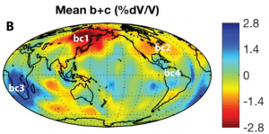
Abstract (from above paper)
Seismic body wave and normal mode analyses have revealed that the Inner Core is solid, strongly anisotropic, and characterized by dramatic quasi-hemispherical differences in elastic structure and attenuation. Yet, despite these discoveries, the highly heterogeneous and incomplete data coverage of the Inner Core has impeded the development of tomographic models even at the longest wavelengths. Here, we use a probabilistic and transdimensional tomographic approach (TBI) on a newly expanded dataset of P-wave travel-times sensitive to the upper 120 km of the Inner Core. The TBI approach yields an ensemble of parsimonious models that simultaneously capture both the dominant hemispheric dichotomy and laterally abrupt velocity variations. Analysis of the model ensemble allows us to determine the locations of the hemisphere boundaries and rule out the presence of hemispheric dichotomy in anisotropy. Instead, we robustly map regional variations in anisotropy beneath Africa and the eastern Pacific, and detect variations at high latitudes suggesting that cylindrical anisotropy may not be adequate for describing the uppermost Inner Core.
The above is the summary of the technical detail (in geophysicsese 😊) on how the image was constructed, and the interpretation of the data.
One doesn’t have to read too many of these geoscience papers to realise why the geosciences are becoming divorced from the minds of the general population. Geologese of this type is the reason.
Geoscientists should spend as much time on getting a crystal-clear message to the general population as on writing the paper. Otherwise, politicians and the general public have no idea of what we’re trying to say and our funding dries up. Getting money for research depends on the providers of funds being told what we’re trying to achieve – in plain everyday English.
I write in colloquial language for this reason.
The results.
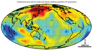
This figure shows the seismic tomography of the surface of the Inner Core at 6,400 km depth.
It has been tidied up but I have left the Continental outlines on so that the scale can be seen.
At 6,400 km depth the scale is only about a sixth of the scale at the Earth’s surface.
This is the best seismic tomography plan that I could find of the outer surface of the Inner Core but it shows no detailed geology.
There is no detailed structural geology plan of the Inner Core on the Internet.
EagleEye © Enhanced images of the Inner Core and discussion of observations.
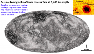
You are now looking at the very first image of the detailed structural geology of the Inner Core.
To produce a plan like this makes one feel very satisfied. A bit like when Captain Cook rediscovered Eastern Australia or when Neil Armstrong felt the moon dust under his shoes for the first time.
This plan was enhanced to show ring structures rather than linear structures. Ring structures from 200 to 1000 km diameter, are seen.
Under the current hot, mobile early Earth scenario it is very unlikely that these ring structures formed from Late Heavy Bombardment (LHB) impacts from 4.1 to 3.8 billion years ago. To have formed from LHB impacts would imply that the Earth was solid and that these rings were the bases of impacts impacting much further up on the earth at 4.1 – 3.8 By.
However, as I’ve stated many times in my papers it is suggested the earth was cool and solid on formation as it would have formed from deep space particles at -100°C.
This is the temperature at which the dust like components of the original Earth would have been in space when they coalesced. I believe that the earth only heated up after these components were compressed and the potassium radioactivity and the pressure heated up the core to about 6000°C.
The current temperature is about 5,600°C and the core is estimated to have cooled by 100°C every billion years. The LHB may have been a mechanical heat catalyst for the initial huge quick temperature increase of Earth. I mean you don’t get 50 km diameter bolides creating 5,000 km diameter ring structures all over Earth, at many levels, without generating great mechanical heat forming stresses.
So, some of these ring structures could be the base of LHB impacts – even through a viscous Outer Core which would behave as a solid under sharp strong pressure!
Another challenge is that it is highly unlikely they would survive such a turbulent history at such a pressure in the centre of the Earth.
An alternative hypothesis for these circular structures is that they formed like sunspots and are upwellings of more liquid iron from the deeper Inner Core. A submerged volcano. Both systems probably operated. See top-right inset.
The image at the top-right shows the typical structure of a sunspot which looks very similar to some of these circular structures in the Inner Core. They differ from impact structures in that they have a flat centre with a corona-type doughnut around it.
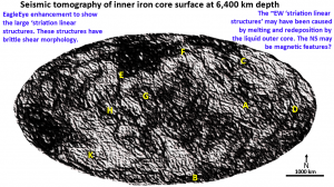
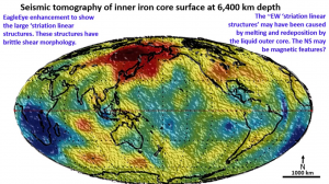
This figure is the result of EagleEye ultra-enhancement to show linear structures.
I stated in my answer to ‘C’ on LinkedIn that I expected to see striations all across the surface of the Inner Core produced by the erosion and deposition of iron/nickel from the Outer Core.
There are many striations and they have a regular pattern to them. The pattern is sinistral. All of the continental scale structures from the surface to the outer core have been sinistral! This seems to be an intrinsic building block in Earth’s evolution?
There are many generations of striations and linears. They tend to fall into 6 major directions.
- WNW direction (A) which appear to be earlier.
The WNW structures correlate with the Earth girdling Tethyan Spiral (O’Driscoll 1980) that is seen at all the other depths in seismic tomography plans.
It is believed that these are structures that formed all through the periods of earth evolution. Why would they form at that particular angle to the earth’s axis?
Their angle of about 25° to the horizontal equator of the Earth suggests that they may be related to the tilt of the Earth’s axis.
- The NNW striation (B) direction which interacts with the WNW direction striations.
The NNW west trending structures are at about 25° to the Earth’s polar axis. They may be related to the interaction of the earth and sun tidal forces acting on the Earth throughout time.
These two structures criss-cross each other suggesting that they are contemporaneous throughout time.
They could also be related to the strong magnetic field force? They trend about 15 degrees either side of the mean which could be related to the varying magnetic field direction?
- There are strong but intermittent NNE linear structures (C) similar to those that cross the Pacific Ocean, North America and Western Europe. The fact that these are present right from the surface of the Earth to the core suggests that they are another structure intrinsic to Earth’s evolution.
It is interesting that these structures are about 25° to the east of the Earth’s rotational axis (opposite to the striations). This suggests that they might be brittle structures related to the tilt of Earth’s axis but created by the sun’s tidal force which acts at this angle to the axis.
- There are branching, fractured EW structures (D) around the equator of the Inner Core. These structures are similar to those seen in the other inner rocky planets Mercury, Venus and Mars. They are most likely related to the differential movement between the poles and the equator on these planets. On Earth they would be much stronger because of the added tidal pressure of the moon.
Earth is a unique planet that has very strong tidal forces from both the moon and the sun and a 23° tilted axis of rotation.
5. There are NS polar axis linears (E) which may be created by the strong magnetic flux at the core??? A scenario could exist where magnetised iron settles out from the cooling Outer Core by following the magnetic flux lines?
- Large sharp arcs (F) on a roughly NS-SW trajectory. Whatever these are they are seen on all of the inner rocky planets and the moon.
When I see these structures trending from plan to section, they relate to flat structures cutting through the Earth.
- There are very distinct concentric circular structures (G, H and K and others) over much of the surface of the Inner Core.
They are very plainly seen and are not artifacts of the enhancement process.
These definitely have the distinctive morphology of impact structures!! That would seem to be a challenge!
These are separate from the sunspot type, doughnut circular structures (figure 3). The only impacts that could have produced these, up to 3,000 km diameter, rings would be Late Heavy Bombardment impacts. It is interesting to speculate how these structures could have survived all this time in the Inner Core.
This suggests that despite its structural complexity maybe the Inner Core has remained fairly pristine and rigid since the Earth formed 5 billion years ago? The liquid Outer Core may have formed a shield?
This structural complexity suggests the Inner Core is heterogeneous. The general perception of the Inner Core is that it is homogeneous iron/nickel. This does not appear to be correct.
This plan shows the superimposed tomographic values and continents.
Other broad domains that can be seen are the light coloured, orthogonal pattern to the north east and north west. It is interesting that they have the same pattern as the continents around the Pacific Ocean 6,400 km above.
I noticed this similarity in all of the seismic tomography plans from the surface to the Core Mantle Boundary and now i see it on the Inner Core? Why?
I suggest that the continents reflect the very basic structural building blocks of the Earth that have been there from the Earth’s formation. This does not fit with the shifting accreting continents of the current Plate Tectonics Theory.
Maybe the Inner Core has preserved these 4 billion year old structures better than the Outer Core, Lithosphere and Crust? The Inner Core is really a planet in itself, all protected from all but the biggest impacts by the viscous outer Core. The Inner Core is supposedly rotating faster than the Lithosphere and so the continents are superimposed only for size and shape comparison.
However, if that is the true position of the continents above the Inner Core the credulity is stretched to believe that they could accidentally line up with these structures at depth. Maybe the rotational speed of the Inner Core is the same as the rest of the earth?
This is just a first pass analysis of the structure of the Inner Core and 99.999% of the work is still to be done by those much better qualified to interrogate the raw data! But this is a good start!
Conclusions.
This exercise was done to show that seismic tomographic ultra-enhancement using EagleEye works on any data almost anywhere. I correctly predicted that the main feature of the inner core surface would be striations and they were!
These major WNW, NNW, NNE, EW and NS structures are the same as those seen on all of the seismic tomography sections and plans from near the surface to the Outer Core. This suggests they are intrinsic to the formation of Earth. They also imply that the Earth was essentially solid when the LHB impacts occurred otherwise they would now be random!
Of great interest are circular corona-like doughnuts with the appearance of sunspots. There are also concentric ring structures up to 3,000 km diameter with the morphology of Late Heavy Bombardment impacts! How did they get there and, more importantly, why and how could they still be preserved?
This has been a most interesting exercise! Being the first to explore an area where no geologic structure has ever been defined is a Captain Cook adventure – a bit daunting, but tremendously exciting and satisfying.

