For a summary of the paper on South America see the previous post – https://www.geotreks.com.au/work/giant-ring-structures/south-america-evolution-surface-to-2900-km-plate-tectonics-targeting-mineralisation/ .
Note. The majority of this paper is a transcription from the video of the AusIMM Webinar at the Western Australian, South West Branch on the 23rd February 2021. The language is thus vernacular and not geologese. This should make it more easily read and understood by the majority of readers.
Additions have been made to expand and clarify sections that were abbreviated due to time constraints in the Webinar. References quoted in the webinar, as well as background papers referenced but not quoted in the webinar, are listed in the text and in the references section at the end of the paper.
The primary objective of these webinars is to promote discussion on new aspects of broadscale geoscience and how these may change our paradigms on the structural geology of Earth, Plate Tectonics, mineral deposits and give new exploration targeting ideas.
· Abstract
South America has some of the most diverse geology and mineralisation on Earth. This paper is an introduction to the South American continent evolution and is based on ultra-detailed, but broad scale research of the South American lithosphere from the surface to 2,900 km depth.
This is the first South American research to use ultra-detailed Landsat, topography, magnetics, gravity and seismic tomography. This great increase in detail enables lithospheric geological structures to be clearly seen in plan and section enabling a 3 D model to be made of the continent. It also enables the lithosphere/crust and mineralisation timing relationships to be observed.
Thus, this research is able to give a much more accurate model of the continent’s evolution than the current hypotheses based on very coarse lithospheric and surface data.
South America has a series of cratons at the surface up to 3.6 billion years old (see the above first figure). The lithosphere obviously would be older.
The strongest ring structure on Earth sits under the centre of the Pacific Ocean at 200 km depth. I suspect that this is where the Mars sized planet hit Earth to form the moon. We can also see evidence of this ring structure at the core-mantle boundary at 1,850 km deep. This structure is still Earth’s largest heat source and probably drives the Pacific Plate Tectonism.
Plate Tectonics and Earth’s evolution rethink needed – The current Plate Tectonics theory suggests that the South Americancontinent progressively accreted over the last 4 billion years. It suggests that the Sao Francisco craton was part of the oldest small, thin, original continent (Vaalbara) which formed 3.8 billion years ago.
The most startling observation in this latest research is that the mantle under Africa and South America has brittle deformation right down to the limits of detailed seismic tomography at the Core Mantle Boundary at 2,900 km depth. This study suggests that the lithosphere, down to at least 600 km depth, formed during the Late Heavy Bombardment (LHB) from 4.1 to 3.8 billion years ago.
Thus, the original South American super-continent has remained an unbroken continent up to the present era. It originated as part of an Earth-wide thick lithosphere. It has survived over the last 4 billion years despite the action, firstly from vertical tectonics and then Plate Tectonics which commenced perhaps 2.7 billion years ago. It shows many generations of brittle deformation to this depth with no evidence of the widespread ductile deformation required by the current Plate Tectonics theory. Thus the plumes as shown on current plans and sections cannot free-flow up through this brittle solid lithosphere.
This requires a complete change to the mechanism of Plate Tectonics, from a free-flowing world-wide drifting of accreting thin surface continents to an original rigid earth being progressively broken up. It will be interesting for us to try and discover the mechanism of how this new Plate Tectonics regime can operate.
Structure – Another far-reaching discovery is the discovery of a 4 billion-year-old immovable barrier extending from the surface to the core and from South America to Alaska. The Andes separates totally different east/west lithospheric morphologies and is where this barrier lies.
The broad structural geology of South America can be explained as a pop-up structure. South America is getting pushed by the Asia-African plate to the west at 25 mm per year but it is also getting pushed eastward by the Pacific plate which moves at about 40 mm a year. That’s a total compression of about 65 mm a year, or about a metre every 15 years. The only way this pressure can release itself is upwards. Hence there are large subvertical compression and orthogonal dilation flat fractures under South America extending to the core.
Mineralisation – this lower pressure regime under South America to the core allows for heat and fluid release.
South America is a rich source of minerals. The main mining fields are located on ring structures and linears observed from the surface to the limits of detailed plan data at 200 km depth.
The mechanism and source of the fluid for most mineralisation may have been discovered by this research. The fluid source is suggested to be from passive resorption of the lithosphere by heat from as far down as the core. This fluid then flows up vertical linear and ring structures to the surface scavenging and depositing minerals along its path. I have defined these structures down to 2,850 km depth.
My research shows that this mechanism also occurs in Australia, North America, China and Fennoscandia. This suggests a close connection between deeply buried LHB impact structures, world girdling linears and mineralisation. Once this relationship has been firmly established, and acted upon for mineral and energy targeting, a leap forward will have been made in exploration understanding, targeting and success.
This Part 1 section describes the relationship of the metal and diamond mineralisation to the linear and ring structures observed in South America at the surface.
We will be looking at the South American continent using the following databases; geology, Landsat, magnetics, gravity and seismic tomography plans and sections. We will conclude by correlating the previous research on Africa with South America by looking at an oblique tomographic section from the Central Pacific to the Central Sahara in Africa from the surface down to the core-mantle boundary at 2850 km depth.
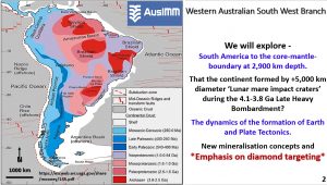
This figure shows the broad geology and geochronology of South America (Chulick, Detweilerb and Mooney 2013). We will explore to the South American Core-Mantle-Boundary at 2850 km depth and see good correlation in South America with the Luna Mare impact process that occurred during the 4.1 to 3.8 billion-year-old Late Heavy Bombardment (LHB)(Taylor Redd 2017).
We will also look at the dynamics of the earth from the crust to the core. It is difficult to estimate how Plate Tectonics can work as we now hypothesise it. We will be looking at new mineralisation concepts with an emphasis on diamond targeting.
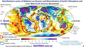
I’ve done research on Australia, North China, North America, Africa and Finland mainly using tomography down to about 300 to 400 km depth. I have published about 40 papers on this research on my website geotreks.com.au. This webinar is on the greater continent of South America which is about double the size of the continent seen above water.
1. South America geology
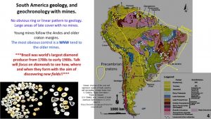
This figure shows the quite complicated geology of South America with the Andes forming on the western side as the Pacific plate gets subducted (Chulick, Detweilerb and Mooney 2013). The rest of the continent is underlain by Archaean rocks (3.7 By gneisses in Sao Francisco craton Brazil (Elson et al. 2019.).
There is no obvious pattern to the mines at the surface. There’s a WNW linear pattern to the mines in the Archaean and the other mines follow the Andes.
South America was the world’s largest diamond producer from the early 1700s to the early 1900s and this talk will focus on diamonds and new diamond exploration targeting methods. No new diamond-fields have been found in Brazil for many years and this research may help in discovering new fields.
2. South America Landsat
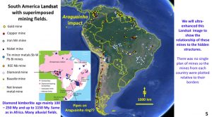
This figure is from Google Earth Landsat with the mines superimposed.
There was no single plan from which I could obtain all of the mines and so I had to locate them in each country and plot them relative to their borders.
I have based my research on real structures and to verify this I’ve picked out a couple of known impact structures that occur in, or near, South America.
The first one is the Araguainha impact (Lana et al. 2008) which occurred about 260 million years ago and supposedly caused the Permian 96% extinction. Although at the surface it is a fairly small impact (40 km) it fell on oil shales and most likely exploded in a huge fire-ball probably 1,000 km across which would’ve had a devastating effect on the earth’s climate and life.
It’s interesting that the diamond mines mostly formed after this impact and occur either side of the impact. However, this may be coincidence?
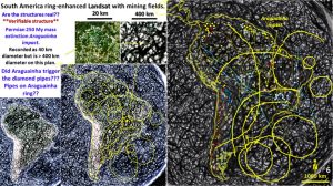
These plans are all ultra-enhanced Landsat and this plan was enhanced to show ring structures which are plotted.
If we could see Araguainha impact structure we should see it on this plan. The top left side inset is Araguainha in Landsat.
Araguainha is represented by the star. The central-top inset shows the ring structures around Araguainha with the known 40 km central structure, a 400 km surrounding ring and a 1000 km diameter surrounding ring.
Very large ring structures can be seen as a west facing ring structure that goes right from the north coast down to Argentina and a SE facing ring structure extending from the Amazon basin with the centre in the middle of the South Atlantic. Both these ring structures are over 5000 km in diameter and the SE facing ring structure centre is about where the mid-Atlantic Ridge is located.
This is the first time these rings have been seen on Landsat and they are very clear. They are similar in size to the rings on the opposite side of the Atlantic in Africa (Watchorn AusIMM talk 2020, https://www.geotreks.com.au/work/giant-ring-structures/evolution-and-mineralisation-of-africa-paper-and-video/?utm_source=rss&utm_medium=rss&utm_campaign=evolution-and-mineralisation-of-africa-paper-and-video) and indeed probably form part of the same set. They have the morphology and the size to be equivalent to the Lunar mares which formed during the Late Heavy Bombardment 4.1 to 3.8 billion years ago (Hiesinger et al., 2010, Taylor Redd 2017).
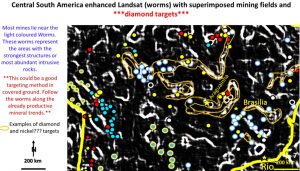
This plan of central South America is ultra-enhanced Landsat using worms. This plan was produced to see exactly where the mines lie.
The worms show where the most abrupt change in Landsat criteria are located (Archibald et al., 1999).
The diamond mines almost without exception lie right on these white worms so the best exploration targeting method to find new diamond mines would be to explore along the worms which lie within the orange outlines.
The metal mines, by comparison, lie in the dark areas. Even when the metal mines are on the worms they lie in dark areas along the worms.
The nickel mines lie adjacent to the diamond mines, generally on the south side.
This suggests that these worms are the most active structural areas over the longest period of time.
The diamond mines are 100 to 200 million years old with some up to 2 billion years (Svisero et al., 2017) and the nickel mines range from 500 my to greater than 2 billion years old. They are the longest lasting, most active pathways for metal and diamond mineralisation. This whole system is similar to those in Africa and Australia.
In the next part of the webinar we will be looking at South America using Topography, Magnetics and Gravity data – with very interesting results!
If you find my research results interesting – or challenging I would love some peer-review comments!
SHARE THIS WITH YOUR COLLEAGUES!

