© Robert Bingley Watchorn 2017
Gold mineralisation of Plumridge giant ring structure. Exploration Potential using radiometrics.
The Plumridge giant ring structure should be an excellent focus for any mineralisation requiring long-lived deep structures with their associated intrusions and fluid flow forming gold mineralisation, copper, base metals, uranium and nickel deposits.
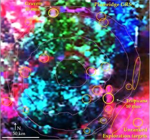
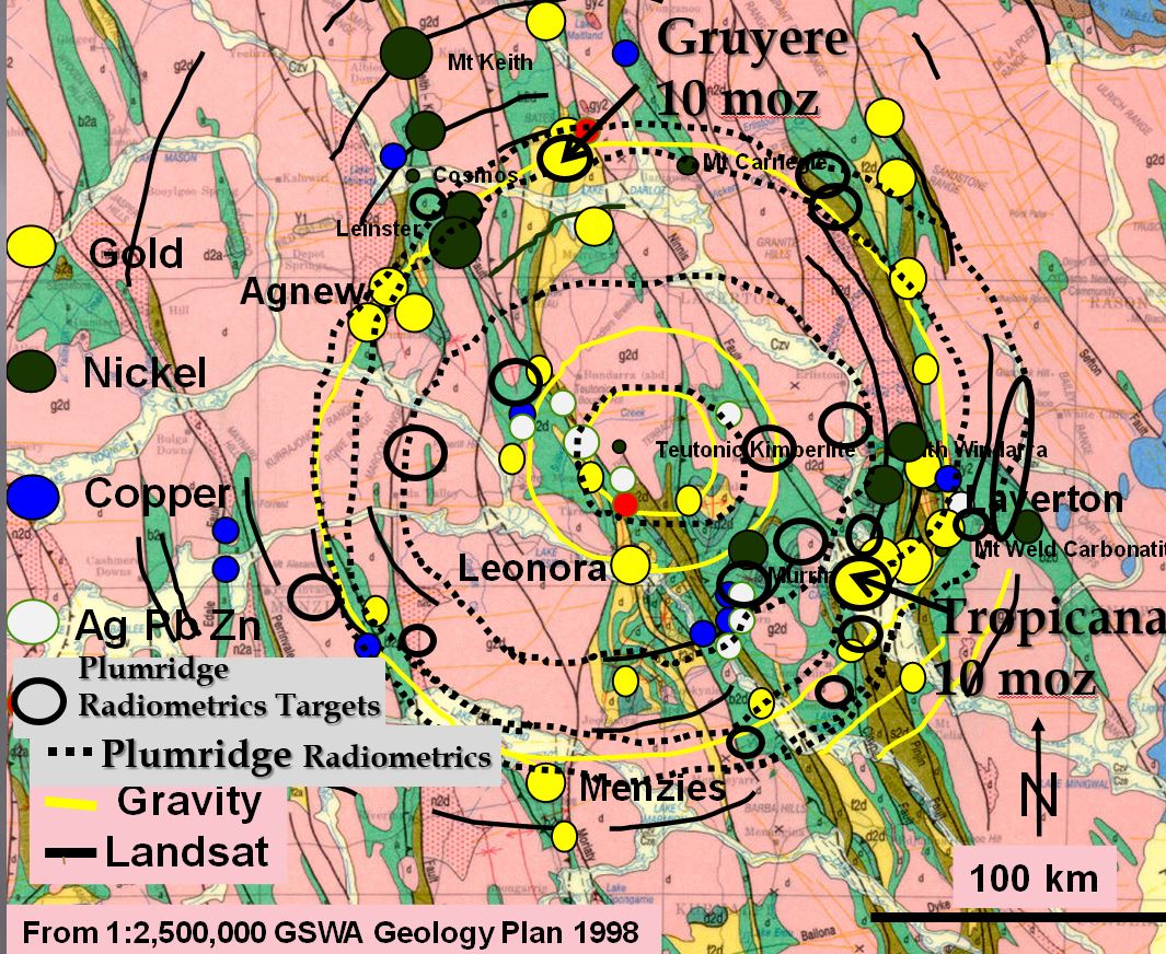
This paper examines using radiometrics for targeting gold mineralisation. Gruyere and Tropicana are the type deposits on which this exploration targeting exercise is based. The Gruyere and Tropicana gold mines are located on strong potassium (K) anomalies with minor uranium (U) content. There are many areas that have a similar potassium/uranium radiometric signature to the Gruyere and Tropicana mines. The majority of these areas lay within the Plumridge GRS outer Gruyere ring. They form a similar pattern to the mines and mineralisation around the similarly sized Watchorn GRS’s Leonora median, and Agnew outer rings. If the distribution of mineralisation on Plumridge giant ring structure is similar to that around Watchorn there are still millions of ounces of gold (and other minerals) awaiting discovery
A hypothesis that the original, now buried, Plumridge giant ring structure was the concentrator of mineralisation in the middle crust and then was the structural driver for this pre-existing Archaean mineralisation’s remobilisation is proposed. Plumridge GRS provides an easy upward path for fluids which then pass through the overlying upper Archaean crust to form Gruyere deposit and through the Proterozoic crust to form the Tropicana deposit.
Gold mineralisation targeting.
This paper describes research on the Plumridge Giant Ring Structure (GRS) and examines using radiometrics for targeting gold mineralisation.
The Plumridge GRS is visible on Landsat, despite limited geological outcrop and semi-desert sandplain cover (see Watchorn YY #2 2017). The present morphology is formed by the Permian ice age plucking out the more highly fractured geology on faults and around the fractured ring structures forming palaeochannels (Watchorn YW #2 2017). Some of the radiometric circular patterns follow palaeochannels but there are sections that are not associated with either the palaeochannels or the regional geology.
The central area shows up as a lighter coloured area in the Landsat and there is almost 100 metres difference in elevation between this centre and Lake Nason which forms an arc around the northern half of the ring structure centre. This is similar to the elevated centre of the Watchorn GRS within the Leonora ring which it is suggested was uplifted by isostasy (Watchorn YW #2 2017). In the radiometrics the Plumridge GRS median 45 km Nason ring is easily observable but the outer 250 km Plumridge ring is more diffuse.
One reader (of the previous paper on the Yamarna GRS (Watchorn YY #1 2017) has suggested that the semicircular granite range north of Lake Nason may be an meteorite impact rim. If so it should be a good place to search for shocked rocks – as it is an outcropping area. Any researcher who has discovered shocked rocks in the Plumridge area now has a source impact structure.
Radiometrics targeting.
This is a brief paper to highlight the possibility of using radiometrics as a first pass mineralisation targeting tool. Gruyere and Tropicana are the type deposits on which this exploration targeting exercise is based. It was noted that there were quite a few areas that had similar potassium/uranium radiometric signature to the Gruyere and Tropicana mines. The majority of these areas lay within the Plumridge GRS outer Gruyere ring. They form a similar pattern to the mines and mineralisation around the Watchorn GRS median (Leonora) and outer (Agnew) rings.
Further research will follow to provide back-up targeting datasets and target ranking tools to refine the exploration targeting.
Proposed formation of gold mineralisation.
This is a paper that invites speculation on, and research on, hypothetical gold sources and fluid travel paths! This area of research has been expanded on in Watchorn YY #3 2017.
The Plumridge GRS is unaffected by the regional geology. The underlying geology is comprised of the NNW trending Archaean greenstone and granite Yamarna terrane which is separated (on the surface) from the Fraser Orogen by the Fraser mobile zone. The Fraser Orogen is Proterozoic on the surface but the relatively undeformed rings suggest that the lower crust is Archaean and has remained rigid throughout the development of the overlying younger crust from >2.9 Ga through 2.5 Ga (Tropicana) to 1.1 Ga in the east. The terrane-crossing structure of the giant ring structures suggest that it did not form as a series of accreting terranes as suggested in Blewett and Hitchman, 2006.
The possibility that these early, now buried, giant ring structures helped focus mineralisation deep in the crust (Reimold and Koeberl 2014 proposed that Vredefort focused the Witwatersrand gold and uranium mineralisation in South Africa) will be outlined in other papers. This pre-existing Archaean middle crust mineralisation may have then been remobilised vertically through the overlying Proterozoic crust to form the mineralised Tropicana position. Evidence of the close correlation of the surface radiometric rings and the huge arcuate vertical structures, seen on seismic section 12 GA T1 passing through Tropicana, supports this hypothesis (Watchorn YY #3 2017).
Further research
- Expand the radiometric targeting of mineralisation to other areas and for other minerals.
- Examine other targeting data (geology, shear zones, magnetics and gravity) that can be used to fine tune and rank the targets.
- Further research on hypothetical gold sources and fluid travel paths
If you like this post or even disagree with it send it on so more can share your views – If you use it in research cite it
| YY #4 Plumridge GRS exploration targeting.pdf | 966 KB |

