Paynes-Find 600 km Giant Ring Structure in magnetics, Landsat, gravity, topography and seismic. Radiometrics of GRS is a Metallogeny Districts indicator. Relationship of GRS to Late Heavy Bombardment. Correlation and targeting of gold Mineralisation.
Magnetics, Landsat, gravity, topography and seismic of Paynes Find GRS
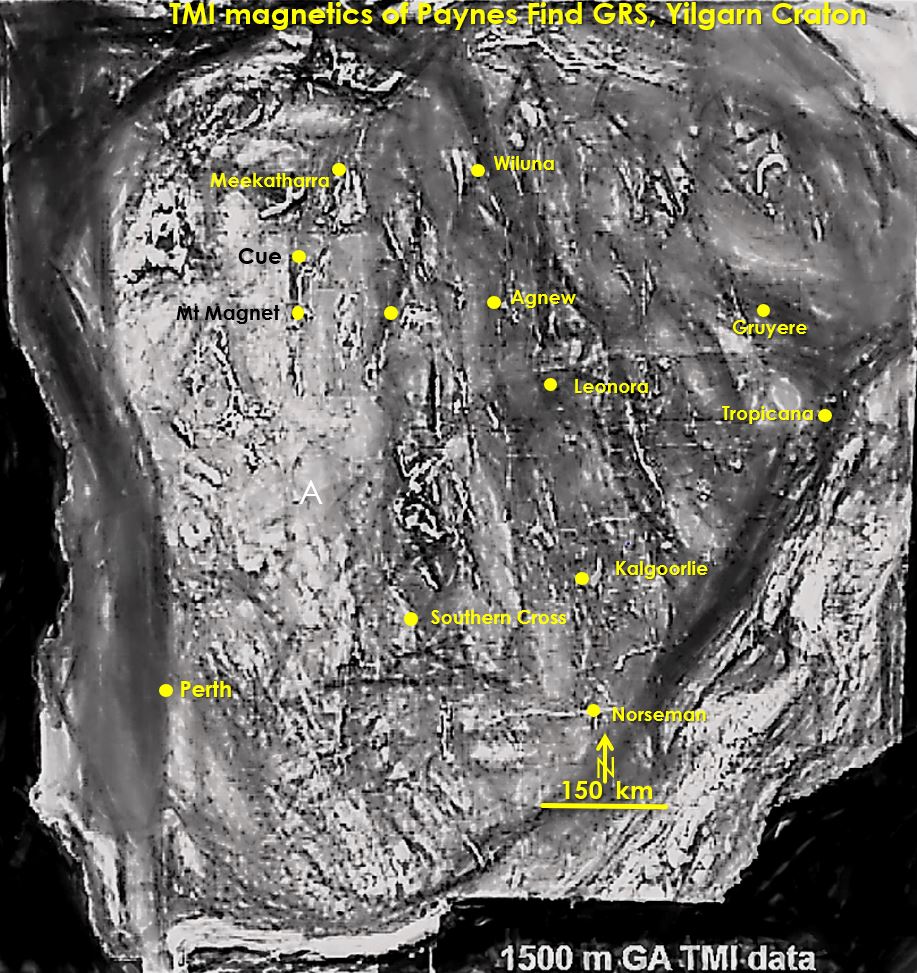
Summary. Paynes Find GRS observed in magnetics shows giant radiating structures (see first image above). Identifying metallogeny districts in the Yilgarn has a basis in definitive radiometric signatures of GRS. Yilgarn craton may have unbroken 4 Ga lower crust and 3.8 Ga middle crust. Late Heavy Bombardment (LHB) zone may be the reflective middle crust. Gold Mineralisation occurs above steep GRS rings.
Abstract.
The overall aim of these papers on giant ring structures (GRS) is to provide an earthscale focus on the underlying architecture of the Yilgarn Craton.
The centre of the Paynes Find giant ring structure (GRS) is located at approximately 29˚ 36’S and 117˚43’E south of the small mining centre of Payne’s Find in the mid-west Yilgarn Craton, Western Australia.
The Paynes Find giant ring structure cuts across all regional geology and there is no large-scale evidence that it is a product of the local geology. It can be observed in the topography, gravity, radiometric, TMI magnetics, Landsat and seismic data. The rings correlate well in these different data sets.
The overprinting relationships of the Paynes Find GRS suggests that it is older than both Malgar and Barrambie GRSs to the east and is older than 3 Ga. However, the rings are more geologically disturbed (and harder to observe) than the rings of Watchorn and Cauden. This may be because the NW Yilgarn has the oldest geology and deepest erosion in the Yilgarn. It has the thinnest surface greenstone upper crust and undergone more intense long-lived deformation and metamorphism. In the southern half of the GRS the ring structures and their associated 2.65 – 2.6 Ga gold mineralisation may have been totally eroded.
Long wavelength TMI data of the Yilgarn was studied to define the underlying fabric and structure. The magnetics show an NS elongated ovoid of homogenised, higher magnetics centred at on Paynes Find GRS. This ovoid is surrounded by a very strong pattern of radiating features which correspond with the main greenstone belts in the western half of the Yilgarn Craton.
It is suggested that the Paynes Find GRS, and the Boondi-Boorabbin and Norseman GRSs in the Central Yilgarn may be have been formed by plumes. The concentric circular features, however, also suggest an impact origin. It is suggested that a large impact may have weakened the then thinner crust acting as a release mechanism for a plume to arise.
The Yilgarn wide GRS have conspicuous radiometric signatures which may form the basis for using the GRS as a basis for metallogenic districts. This should lead to targeting for the specific associated minerals within these areas. The variation in the GRSs radiometrics may suggest impacts of varying composition, and age, as proposed by Voosen in 2018.
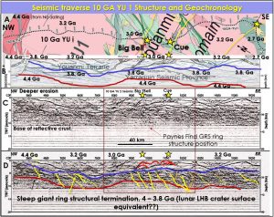
There is a correlation between steep, deep structures in the 10 GA YU 1 and 10GA YU 2 seismic traverses (see seismic image above) with Paynes Find GRS rings with structures underlying the gold mineralisation, particularly in the Cue, Big Bell and Sandstone areas. Above these structures antiforms are formed which is one of the criteria for gold deposits found in recent research.
An analysis of the age and origin of the Yilgarn Craton and the GRSs suggests the craton has a relatively unbroken lower (> 4 Ga) and middle crust (3.8 Ga). The Paynes Find GRS rings show the concentric pattern of an impact structure but there is also the radial intrusion/extrusion pattern associated with a plume structure.
There is a strong belief among geoscientists that early impacts were quickly destroyed by early Earth’s mobile crust and erosion? However, Stern 2015, argues that true Plate Tectonics didn’t commence until the Neoproterozoic and Bercovici, Tackley and Ricard in 2015 argued that there is ample evidence that the Earth only underwent a transition to more global plate tectonics by 3 – 2.7 Ga. Either way plate tectonics probably only commenced on a large-scale after 2.7 Ga which postdates the time of the last researched GRS in the Yilgarn and is post Yilgarn craton formation. Furthermore, the crustal structure observed in the seismic traverses across the Northern Yilgarn does not show big disruptions to the crustal structure in the middle and lower crust.
If the GRS were formed by Late Heavy Bombardment (LHB) impacts the actual LHB zone may be the reflective middle crust? Reasoning. There is a detachment zone between the middle and upper crust. This detachment zone (blue in the above figure)may have been the original LHB level at which the giant ring structures formed. Many of the steep, east dipping structures terminate on this zone. If the GRS were formed by LHB impacts this detachment zone would be the equivalent of the cratered, present day moon surface of 4 – 3.8 Ga age.
The deeper diffuse boundary (green) between the middle and lower crust, which is where the main regular moderate east dipping reflective structures extend down to, would be a more likely LHB level based on the geochronology of the Narryer Terrane. Maybe this middle reflective crust was formed by an impact/ extrusion/impact extrusion sequence during over the 200 My LHB from 4 – 3.8 Ga?
It is suggested that these early, now buried, subvertical, giant ring structures helped focus mineralisation originating from deep in the crust to higher levels. This Archaean middle crust gold mineralisation may have been the source material for gold that was then remobilised vertically through the overlying middle and upper Archaean crust as the Yilgarn craton underwent later tectonic events. The seismic traverses show that these are the only available steep structures that extend from the mantle to the surface. This mechanism may have formed the current, 3 – 2.6 Ga current surface mineralisation.
The premise for gold exploration targeting areas are intersections of favourable stratigraphy and structures with Paynes Find, Barrambie and Malgar giant ring structures. New mineral targeting should encompass already recognised favourable structural and lithological locii around the GRS rings.
| aa Paynes Find GRS correlation with metallogeny LHB and mineralisation.pdf | 3 MB |

