Geochronology, Cauden GRS structure and mineralisation, Eastern Goldfields, Yilgarn Craton.
Cauden GRS location and size.
The centre of the 370km diameter Cauden giant ring structure (GRS) is located at 31˚ 40’E and 119˚40’S, about 60 km SSE of Southern Cross. Three previous papers on research on the Cauden GRS, geology and broad mineralisation have previously been described on the author’s website https://www.geotreks.com.au/work/giant-ring-structures/yc-1-cauden-new-yilgarn-craton-giant-ring-structure-relict-impact-superplume-structure/
This paper focuses on Cauden GRS in the Eastern Goldfields from Mt Pleasant – Kalgoorlie – Norseman goldfields. The possible geochronology and genesis of the Cauden GRS and its interrelationship with the Malgar GRS is discussed.
Genesis?
Kalgoorlie area stratigraphy shows major unconformities and subsequent very high energy lithologies from 2.676 to 2.69 Ga which Blewett in 2012 suggests may have been part of a catastrophic crust forming event. Could there have been an impact at this time? Was Cauden GRS that late impact? Research suggests this is unlikely.
The Cauden GRS appears undistorted by the regional geology which normally would imply that it is later than this geology. The Cauden ring traverses geology that has an age difference of up to 0.8 Ga. The northern Youanmi terrane has surface rocks that contain zircons from > 4 Ga rocks (Wyche et al, 2004). The structural uniformity of the seismic, and seismic tomography, traverses across the whole Yilgarn suggest these older rocks underlie the whole southern half of the state.
This is an enigma as if it is an impact then it should present shock structures at the surface. So far none have been found apart from a shock metamorphic breccia in drillhole ELV 071 near Leonora which is believed by the author to be related to Watchorn GRS.
Geochronology – Cauden GRS age is ?
Field research in 2016 and 2017 suggests that Cauden formed early and was active through all subsequent deformation events, by re-activation of the original ring structure as palimpsests or Trans-Lithospherical structures. The mechanics of how this operates is suggested in Watchorn YY #4 2017 figure 4 where deeper, middle crust, ring structures are re-activated through to the current surface. Field studies in 2016 around the Cauden GRS suggest the rings formed before gneiss development between 3.01 – 2.72 Ga and before the later 2.9 and 2.72 Ga greenstones.
Relative age of Cauden and Malgar GRS.
The timing relationship between the Cauden and Malgar GRSs is observed in the Kalgoorlie area. There is a strong association of Cauden residual gravity rings with the Ora Banda – Kalgoorlie – Norseman late greenstones, volcanics and sediments. Cauden is a later ring structure crosscutting the earlier Malgar rings. There is a dextral (flat S) interference pattern between the Cauden and oblique Malgar rings.
Comparative studies of Victory, Wallaby and Tropicana mine seismic sections.
Structural comparisons of the Mt Pleasant mines with the Victory mine at Kambalda, the Wallaby mine near Laverton and the Tropicana mine east of Laverton are presented.
Mt Pleasant seismic traverse
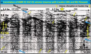
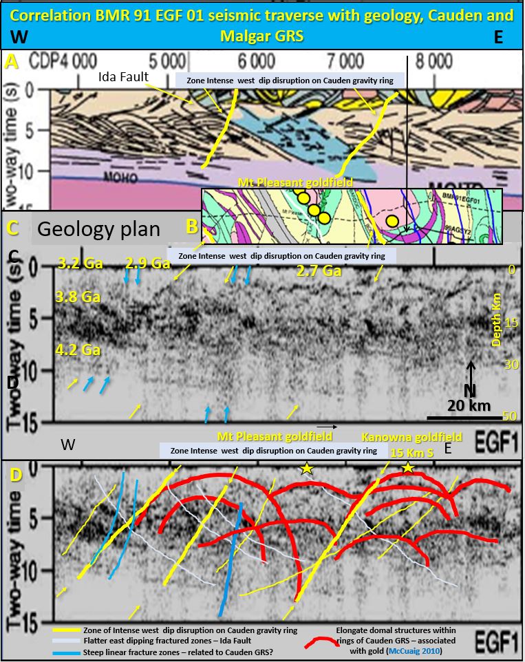
BMR 91 EGF 01 across the Eastern Yilgarn 40 km north of Kalgoorlie has steep arcuate and domal structures that correlate with the Cauden and Malgar giant ring structures. There is a steep west dipping 25 km wide fracture zone (disrupted lighter/less reflectivity) associated with the Cauden GRS outer ring that underlies the Mt Pleasant mining field. Elongate domes north of Kalgoorlie are associated with the antiforms seen in the BMR 91 EGF 01 seismic section. The domes correlate with the Mt Pleasant and Kanowna mining fields and also correlate with the top of two large semicircular structures. See above images for Mt Pleasant seismic interpretation.
Victory seismic traverse
St Ives_VIC shows a central elongate antiformal domal, fracture zone at the centre of the anticline that has no movement but forms a very fractured good fluid pathway. Gold mineralisation in the Eastern goldfields forms very late and as this fracture zone overprints all other geology it is the most likely pathway for the gold mineralisation. All major structures in the seismic section dip steep west similar to those associated with the Cauden GRS on seismic traverse 91 EGF 01.
Wallaby seismic traverse
mig 01 NY2 has an elongate antiformal dome under the large Wallaby mine. The steep west dipping fracture zone at the centre of the anticline has no movement but forms a very fractured good fluid pathway. This correlates with the Watchorn Laverton ring. These structures are similar to those associated with the Cauden GRS on seismic traverse 91 EGF 01and almost identical to those under the Victory mine in St Ives_VIC seismic section.
Tropicana seismic traverse
12 Ga T1 arcuate structures correlate well with the outer Plumridge GRS ring. They are observed as large arcuate disruption zones that curve down through the Moho which is at a depth of 40 km. These two structures terminate at the estimated top of the Archaean middle crust but extend through the Proterozoic crust surface as much weaker structures or fractures. Tropicana mine is associated with the outer Plumridge ring on this Proterozoic surface.
Dome and basin structures – are they sections of toroids following the rings?
The interpretation of the seismic traverse across Cauden, Watchorn and Plumridge GRS is that these large steep arcs are the subsurface expression of the GRS surface rings and the semi-circles on the seismic vertical sections are the upper sections of large toroids. The elongated domes may form around the annulus of the giant ring structures as toroids. The domal effect may be the result of an interference pattern as the toroids meet other crosscutting ring structures or NNW shear zones. These may form dome and basin structures ideal for nickel and gold deposition.
Summary of timing evidence.
The timing of the Cauden and Malgar GRS was ascertained by the following structural geology evidence. They formed during, or just after lower 4.36 – 3.7 Ga crust formation, before peak metamorphism and the formation of the 3.01 – 2.75 Ga gneisses. Structures aligned with both giant ring structures were recognised in late 2.67 – 2.60 Ga granites and the 2.47 Ga Jimberlana Proterozoic dyke at Norseman. There were post Permian glaciation erosion structures on the Leonora ring east of Leonora. This is evidence that the Cauden and Malgar GRS were structurally active from > 3 Ga to the present time.
Morphology comparison with Chixculub impact.
The morphology of the giant ring structures in both plan and section is identical to that exhibited by Chicxulub meteorite impact. It is suggested that the Cauden, Watchorn and Plumridge impacts occurred during the Late Heavy Bombardment between 4.1 – 3.8 Ga and that the lower crust seen in the seismic sections is of this age.
Further research will include;
Obtain good image of BMR 91 EGF 01 seismic section. Examine all the other seismic sections in the Eastern Goldfields for comparison with the current research results. Further examine the correlation of other mining centers with the seismic evidence and with the GRS rings. Plan exploration targeting based on results.
For a much more detailed explanation of the above research open the file below ———
Share with your colleagues and follow the posts for more ground breaking research results that are used by increasing numbers in exploration targeting.
| YC #4 Geochronology and mineralisation of Cauden GRS in the Yilgarn Craton (AutoRecovered).pdf | 2 MB |

