China Geology
China geology pilot study research examines the structural geology of North China by comparing the surface geology, the plan tomography from 70 through 195 km depth, an EW and two NS tomographic sections.
This research follows similar research in Australia https://www.geotreks.com.au/work/giant-ring-structures/australia/australian-lithosphere-tomography-75-to-300-km/ and North America https://www.geotreks.com.au/work/giant-ring-structures/north-america/geology-north-america-300-km-depth-seismic-tomography/
North China craton 90 km depth tomography and Lunar mares, comparison of geology and geochronology.
Concentric giant ring structures of a similar size and density to the Lunar mares were outlined by tomography from 70 to 195 km depth.
The largest impact structures (X and A) are 1000 – 2000km in diameter and form the core of the North China craton and the Lunar mare areas (with Australia superimposed for scale). The China giant ring structures and lunar impacts are of a similar size and density.
The moon mares were formed during and after the Late Heavy Bombardment (LHB) that engulfed the inner solar system from 4.1 – 3.8 Ga with more minor impacts through to 2.6Ga (from https://en.wikipedia.org/wiki/Lunar_geologic_timescale)
There was probably more than 100 km thickness of heavier mafic rocks extruded during the intense Late Heavy Bombardment (LHB) period. The LHB extended over 300 million years from > 4.1 – 3.8 Ga. This only assumes 330 metres of extrusive every million years. As the lava fields would be flat and with no continental drift forming mountain building for rapid erosion this is a conservative estimate.
North China craton geology in tomographic section.
Volcanism, vertical tectonics, Rayleigh–Taylor flow and subsequent (post Archaean) erosion would give great buoyancy to Archaean cratons. It is suggested that most of the largest LHB impact created cratons still exist on Earth in the lithosphere because of this great buoyancy.
The three tomographic cross-sections showed a series of stacked bowl-shaped structures which correspond to the giant ring structure rings on each plan level. Uplift dome structures occurred under the giant ring structure centres.
The timing of these relatively undeformed structures is before the Hadean (> 4 Ga) based on their stratigraphic position beneath the crust and Moho. They most likely formed during the Late Heavy Bombardment (4.1 – 3.8 Ga). There has been no comparable world – wide giant ring structure forming event since that time.
The ring structure morphology, both in section and plan, is that of giant impact structures and the only period of dense impacts was the Late Heavy Bombardment from 4.1 – 3.8 Ga. All evidence points to their formation by LHB impacts. The lithosphere that they impacted into has to be older and would have formed between the separation of the Earth and moon at 4.5 Ga and the earliest LHB impacts at 4.1 Ga.
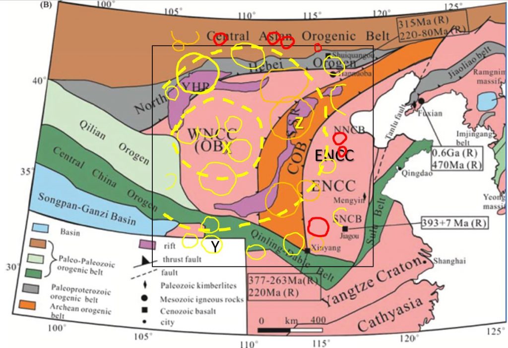
China surface geology comparison with tomographic 90 km depth and section A geology
The ring structures however show no fragmentation (in plan or section) since their formation in the LHB. The GRS are still circular suggesting the Lithosphere at least has been rigid since ~ 3.8 Ga.
The North China craton geochronology has been estimated as follows;
Plan. The North China craton surface crustal age ranges from 0.22 to ~ 2.6 Ga and forms a series of NS – NNE trending deformed orogens over the centre of the craton and approximately EW orogens on the north and south boundaries. The more upthrust areas in the east are the oldest. Conventional geology principles suggest that even older lithologies lie underneath.
There are several circular topographical features in the NW of the craton that correspond with ring structures (X and the GRS to the NNW) at the 90 km depth. The Huang He river follows the west and north boundary of giant ring structure X. The Huanglu Gaoyuan massif lies over the centre of X.
This is a similar structural geology mechanism to the deeply buried giant ring structures in Australia that exert an influence on the surface geology through to the present by Trans-Lithospherical structure propagation. The GRS centres are uplifted and the annulus is more fractured allowing magmatism (and mineralisation) up the fractures and more rapid erosion forming surface basins and river systems following the annulus.
The YHR and SSR rifts, which are located in the annulus of giant ring structure X, may follow these Trans-Lithospherical structures.
Section. The seismic tomographic sections show the vertical Archaean geological structure and the probable geochronology of the geological layers in the crust and Lithosphere.
The above morphology strongly indicatives that the giant ring structures were formed by impacts during the LHB.
For a much more detailed look at the North China Craton download the linked file below —–
| CN #1 China North Craton tomography. 60 to 200 km depth (AutoRecovered).pdf | 3 MB |
Share this paper with your colleagues – especially the Chinese ones – if you find it interesting or useful for discoveing the next mine follow this website as theres plenty more to come.
The South African Cratons will be investigated in the next paper – that should be interesting!! Plenty of controversy and different ideas on their formation and how the mineralisation forms!
Happy hunting 🙂
Bob Watchorn

