Australian Lithosphere research.
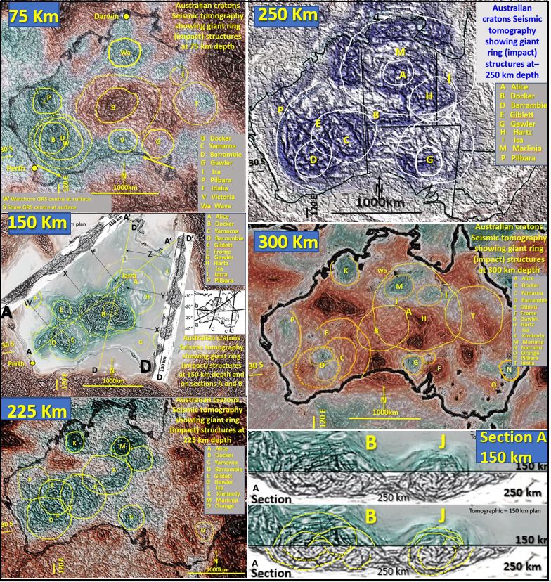
Australian Lithosphere research of giant ring structures (GRS) from 75 km down to 300 km depth shows that they are an integral part of the structural geology of Australia. They are in fact the largest, possibly most important, geological structures in Australia because of their control of regional structures and mineralisation.
A series of papers researching the seismic tomography of all the continents in plan and section from the surface to about 400 km depth has commenced. The North American continents has had a paper describing the tomography at 60 km depth (Watchorn CS # 1, 2019 published in May on https://www.geotreks.com.au/).
The 75 km depth tomographic image shows interpreted giant ring structures across Australia. The names of these ring structures is provisional as there is no record, apart from my papers, that any of them have been documented in detail. I have given them new names to differentiate these from structures in previous research. The blue/grey, that correlates with the giant ring structures, indicates drier, harder rocks that have higher seismic wave velocity. The brown correlates with wetter, softer rocks.
The brown in central Australia correlates with the deep Proterozoic lithology that occurs over the Central Australian giant ring structure (B) that starts at 80 km depth. The large central giant ring structure (impact) in the Superior Craton (Watchorn CS #1, 2019) also has similar deep Proterozoic sediments/extrusives over it.
There are giant ring structures (impacts) observed in the same position on the above 150 km level as on the 75 km level but there are also giant ring structures that don’t correlate with the 75 km level.
Because the Earth will have had the same protracted Hadean impact history as the moon there will be many layers of giant impacts buried beneath Earth mares (buried LIPs) which will be much more extensive (and more deeply buried) than the Lunar mares. Each layer will have giant ring structures with different locations (impact location) as is already seen on the 75 and 150 km levels. The giant ring structures have morphology that suggests at least three periods of impacts.
On the moon there are three main episodes of impacts that have been recognised and dated.
The first is the Nectarian (purple) of about 4 Ga which form the lowest layer of craters on the visible moon surface. These craters were the last formed in the LHB. There would be deeper buried craters (pre- Nectarian) back to the moon’s formation at 4.5 Ga. On Earth these most likely correlate with the huge underlying structurally coarser giant ring structure (impact) A in Central Australia (see paper on website).
On the moon the middle layer (blue) is the Early Imbrium of 3.2 to 3.8 Ga. These may have formed at the end of, or postdate, the LHB. On Earth this middle level most likely correlates with the later, circular, more structure filled giant ring structures J, B, D and E seen in the upper levels of the Australian plans and sections in the paper on the website.
On the moon the Late Imbrium craters (light blue to teal) from 3.2 – 2.6 Ga may also correlate with these later structures in Australia.
The giant ring structure (impact) outlines are still seen. However; they are less circular but still have brittle NNE and WSW internal structures. The shallowest brown mantle rock areas are located beneath the largest giant ring structures seen in the 75 and 150 levels.
The giant ring structure (impact) outlines are still seen. They are less circular (slightly ovoid east west) and have fewer brittle internal structures. These internal structures now trend more NNE, NW and EW.
The base of many of the giant ring structures are replaced by mantle (brown) lithologies. The only cratons remaining at the 300 km level are the north section of A, the Yilgarn Cratons (D) the Gawler craton (G), the Kimberly craton (K) and the deeply buried Tamworth (T) and Deniliquin (De) cratons and the base of the deeply eroded Pilbara (P) craton.
Genesis of Hadean/Archaean cratons and Lithosphere.
Australian Lithosphere research shows giant ring structure near Tennant Creek, Northern Territory (A), the GRS near Giles, Western Australia (B), the Yilgarn Craton (C and D) are all compound GRS with several centers forming large 1000 km diameter ovoid structures. The GRS morphology in plan and section confirms the hypothesis that the Australian Lithosphere (cratons) was formed by multiple impacts over a protracted period similar to the Lunar craters. The structural geology of the sections shows the Lithosphere is continuous across Australia.
Australia tomographic 150 plan interpreted A tomographic section showing giant ring structures in both plan and sectionThere is good correlation of the -150 km level plan giant ring structures with down-facing arcuate structures observed on the seismic tomographic sections A and D.
The structures on both plan and section the A-A’ section shown correspond with the ring structures J, B and D. Even individual rings correspond in plan and section in Jarra GRS (between Tennant creek and Alice Springs).
B (Docker GRS near Giles, Western Australia) is a compound GRS with several centers forming a large 1000 km diameter ovoid structure. The section reflects this complexity with many bowl arc structures at different levels and their morphology confirms the hypothesis that the cratons were formed by multiple impacts over a protracted period similar to the Lunar craters.
Share with your geoscience colleagues and any one interested in the early formation of the Earth —– Read the full well illustrated cutting edge paper from the file below —–
| AC #2 Australian seismic tomography of Arhchaean cratons 75 to 300 km depth.pdf | 4 MB |

