Figure 5f. Kalgoorlie Norseman area, EagleEye structural geology correlation with published geology.
Objective.
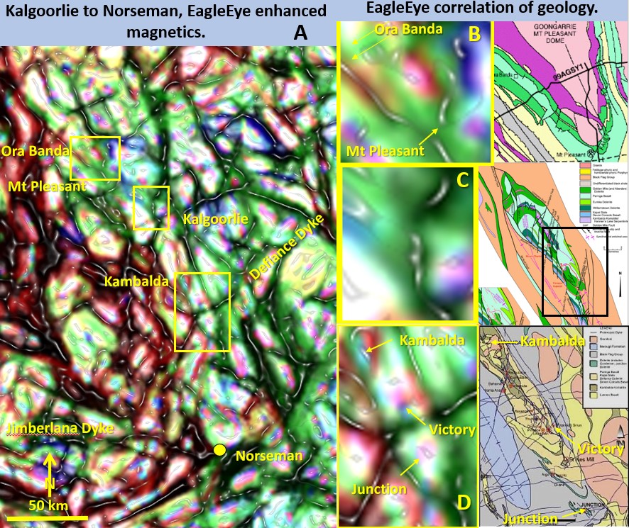
We will now look closer at Ora Banda (B), Kalgoorlie (C) and Kambalda (D) EagleEye structural geology’ correlation with published geology. The areas are shown as yellow rectangles on plan A.
Research results.
B. Ora Banda. The geology is dominated by the south plunging Mt Pleasant dome with a core of granite. The EagleEye structure shows a south pointing V shape of similar dimensions.
C. Kalgoorlie. The geology to the north of Kalgoorlie is dominated by the south plunging Boomerang Anticline and is cut off south of the Superpit by NS trending strong faults. This is what is seen on the EagleEye inset D.
D. Kambalda. The geology from Kambalda to Junction mine consists of the Kambalda Dome, at Kambalda, and the Kambalda anticline through past Junction. This forms an elongated south pointing V. This is what is seen on the EagleEye image D.
Conclusions on geology and research methodology.
Although the original data is only a 261 KB colour contour geophysical image enough data has been extracted to give reasonable renditions of the geology at Ora Banda, Kalgoorlie and Kambalda. ‘How can this be done’ I have been asked many times. The key is the pattern recognition Microsoft software which must be incredibly powerful to be able to extract the structural detail from such a apparently data poor original image. I don’t know exactly how the Pattern recognition software works except that it has proved reliable in much harder tasks than this one. I don’t know exactly how the electrical systems on this computer work – just that they do – and thus I use it.
I have been told the EagleEye method is pseudoscience just because I don’t know the algorithms of the Microsoft software even though it gives verifiable results. If we gave up on geoscience research based on not knowing the mathematical criteria then nothing would ever be achieved. That currently seems to be the case in this area of geoscience research. Too much math and not enough trial and error.
The software works and only Microsoft knows the algorithm. Wouldn’t it be great if the geoscience industry got hold of this Microsoft or a similar, MRI type algorithm to obtain similar, or much better, results than EagleEye?? As I’ve said before – nothing would make me happier!
Over the next few posts I will gradually hone in on the mines until I can present the structural geology of the 4 x 2 km Superpit relatively well defined – and a bit of a surprise! Coming from a Australia wide original colour contour plan? No way!
Until then 🙂 Diligent algorithmic research.
Cheers
Bob