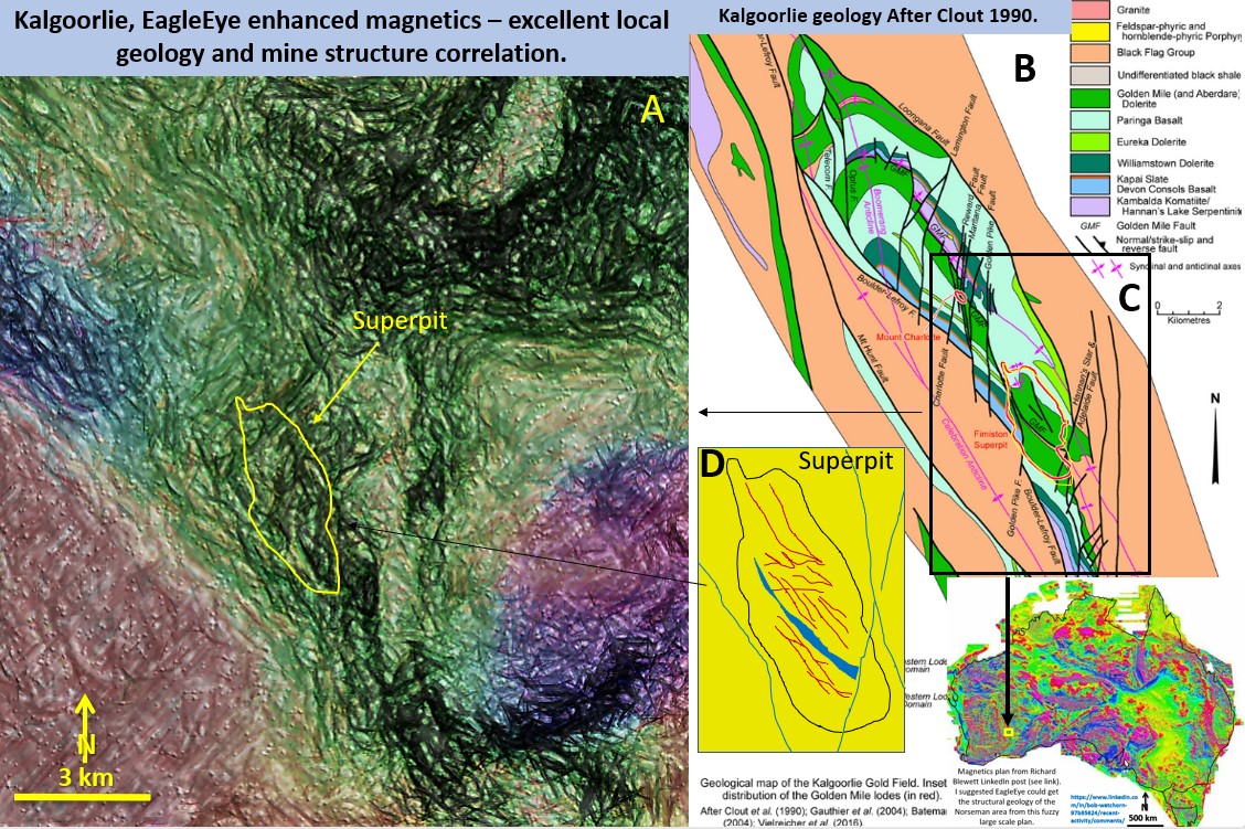
Figure 5g. Kalgoorlie and Superpit area, The correlation of EagleEye structural geology and lodes with published geology.
Objective.
To show that by enlarging the Australia wide colour contour magnetics plan almost infinitely that the EagleEye method of image ‘restructuring’ will give detailed structures of each area being investigated. In this case the original image has been enlarged from 4,000 km across to 10 km across 0r 400 times and yet the structural detail is infinitely better – if it is real! detail.
Are the structures real?
I was an underground geologist with KLV from 1972 – 76 and followed and mapped in 3D many of the lodes, mainly on the Western Lode system, and know the geometry of the structures well.
Comparing plan A the EagleEye enhancement, and plan B with particular reference to the Superpit (inside inset C and D) the following structures are compared.
1. Prominent NS and NNE faults are shown south of the Superpit on both plans.
2. Weaker NNE faults are noted north of the Superpit and crossing through Mt Charlotte location.
3. SW of the Superpit and trending NW to SW of Mt Charlotte is a series of faults that trend NS and dextrally offset the stratigraphy west-side to the north. This is the well documented Boulder Lefroy Fault.
4. One kilometer NE of the Superpit the NW trending Loongana fault is clearly seen on both plans.
5. One kilometer East of the southern end of the Superpit there are two strong NS faults cutting through the granite (or felsic volcanics) clearly observed on both plans A and B.
6. Across the southern East side there are a series of NNE faults on both plans.
7. Inside the Superpit outline there are NNW, NW and EW structures that correlate with the main, Caunter and Cross lodes. these are not as clear but can be seen. They will be investigated further in the next post.
Conclusions
There are many structures that correlate between the two plans. Absolutely nothing can be observed of structures on the original plan which has been magnified 400 times.
To me it is truly amazing that this occurs. The Microsoft pattern recognition software must be really powerful!
I had a good trawl through the open public internet and couldn’t find any really good aeromagnetic plans of the Kalgoorlie region. They can be got from government and academic sites, some free and some not.
There are no solid structural geology plans that show all these structures that I could find. Correct me if I’m wrong – and send me the plan.
Being able to get detailed structural geology from the broadest possible scale plans opens up many new avenues for government, academic and exploration companies to get fantastic geology for NOTHING.
Next post.
In the next post we will zero in a bit more on the Kalgoorlie Golden Mile Superpit which has produced more than 60 million ounces and learn a bit more about its structure. I am interested to see what I can pull up! I know the area well from the surface to the 3750 level and helped get the first mini Superpit predecessor pits going, on B lode, 4 lode and Drysdale lodes, in 1975.
Cheers
Bob

