Atlantis, geological research in the Seville area, Spain.
Atlantis background.
The Egyptian priests stated Atlantis suffered an earthquake and vanished beneath the sea in one day about 9,000 years before their time 490 BC or about 11,500 years ago.
It was believed Atlantis was a myth. That there were towns existing at that time with sophisticated art and sculptures is shown by ancient Jericho in Israel/Palestine, the ruins of Göbekli Tepe in Turkey and 11,00 year old pottery artefacts at Huelva near the proposed Atlantis site.
Atlantis description
Atlantis city was described as consisting of a series of 5 concentric canals and 6 land areas. The city was located in the centre and was 1 km in diameter. There was a narrow canal that cut straight in from the outside to the centre that came from the ocean and a causeway from the mountain palace. The calculated 14 km diameter concentric circular plan of Atlantis is large enough to be amenable to structural geology research that might define its possible location more closely.
The mention of a shoal of mud stopping access after inundation (even after 9,000 years) suggests an estuarine or lacustrine environment similar to the Guadalquivir Basin entrance even today. It was not an open ocean where the mud would quickly be washed away to leave sand and rocks.
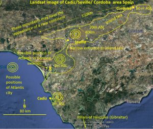
Beyond Atlantis was a continent described as being about 550 km length by 330 width. This measurement equates approximately to the area of Spain and Portugal west of the old Pillars of Hercules (Gibraltar). The map of the known world by Greek Hecataeus in about 500 BC (about the time of Solon’s visit to Egypt) suggests little was known about what lay beyond Gibraltar. Spain, if seen over a large ocean-like lake in a flooded Guadalquivir Basin, might appear as a new continent.
Why Seville area?
The area has always been a favourite site for Atlantis and has all of the ingredients for an early advanced civilisation. It has a safe island location, metals to make implements and weapons to trade. There are abundant metals (with the wealth they bring) in the immediate area with the huge First Quantum minerals Las Cruces copper mine. Mining in the area is old, very rich and would have had outcropping copper metal to mine 11,000 years ago. There are recorded workings back before 3,000 BC. Tin, the other essential component of bronze was panned in the local rivers. The rich, flat, well-watered land of the progressively filling-in Guadalquivir basin was ideal for food production.
Historically recorded Tartessus culture traded with the Phoenicians from 9,000 BC (11,000 years old Huelva pottery). Were all these known cultures part of the advanced “Atlantis civilisation”?
Recent Research.
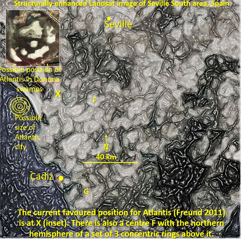
A team, working on a documentary for the National Geographic Magazine led by Professor Richard Freund, claimed to have found possible evidence of Atlantis in southwestern Andalucia near Seville/Cadiz. The area they may be researching in the marshlands of the Doñana National Park is at centre co-ordinates 36˚ 57’ 24.34” S, 6 ˚ 18’ 42.55” W. and is about the right size for the centre and first canal of the described city. This is the only readily seen circular geographical feature that matches the description of Atlantis in the whole area.
Author’s research
The conclusion that the area around Seville/Cadiz is the most likely location of Atlantis prompted the author’s research into the structural geology of the broader area. Cadiz/Seville area has been geologically, and seismically very active and a subsidence 11,500 years ago is possible.
This research using Landsat images of the area concludes it is a recent area of geological activity and there is evidence of the claimed circular canals and landforms, both on a small or large scale. The Landsat images were enhanced using the techniques used by the author in research on giant ring structures in the Yilgarn, Western Australia.
The district between Seville and the Atlantic Ocean has many circular features in Landsat. Their mode of formation and why they are preserved through the recent alluvium is of interest. There is no doubt however that they exist in the Landsat data. Are they part of an ancient caldera that has sunk? This may have formed a series of circular canals and a central island similar to the Polynesian volcanic islands as they sink. Thus, Atlantis may have been a geologic formation that was ideal for settlement.
Seville north also fits the description of Atlantis if there was a large interior sea extending 200 km ENE to Cordoba. It is inside a narrow entrance (Seville) and close to mountains in the North. The geology shows sets of ring-like features around three centres. These areas should be investigated on the ground. Large features observed are probably geological and not man-made but they may have been topographically suitable for the formation of the ring canals and islands described by Plato.
The conclusion is that there is evidence of concentric circular structures in the Cadiz/Seville area beyond Gibraltar where Atlantis was reported to be located by the Egyptian priests. These structures are similar in size to those reported by the Egyptian priests of the 14km diameter size of Atlantis city.
Follow up research;
- The selected areas should be field tested for artefacts of Atlantean origin.
- Other geographical, geological and geophysical data should be analysed to fine tune the Landsat evidence.
- Available core drilling on the centres of the circular structures could be undertaken to;
- Establish a geochronology for the area to ascertain if there is a Guadalquivir Sea that is consistent with the alleged 11,500 years age of Atlantis.
- Find the original solid ground level before inundation at 11,500 years ago.
- Test for evidence of tsunami at this or other levels.
For the complete research paper follow link below.
| Atlantis research.pdf | 1 MB |

