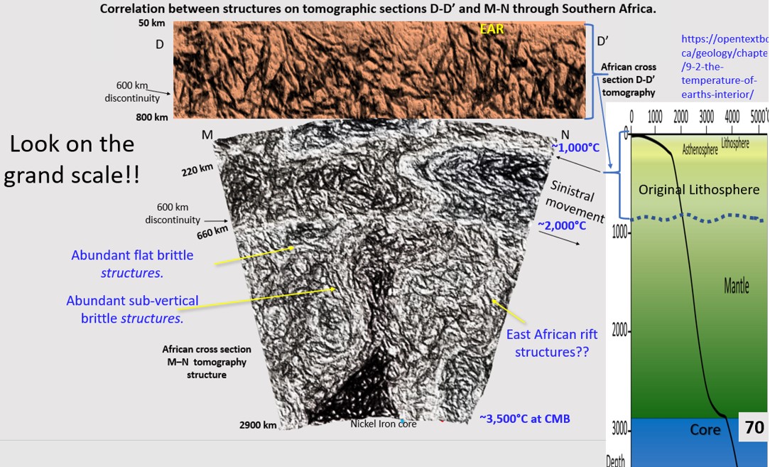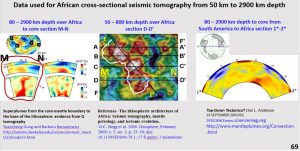
This figure shows the datasets used to view the lithosphere under the African continent down to the Core Mantle Boundary at 2900 km. The lithosphere directly under Africa used Yuancheng Gung and Romanowicz 2002 and the area under the Atlantic Ocean and South America used Anderson 2001.
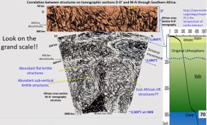
This figure when I first produced it was a great geological surprise. It shows the brittle structures seen in the first 800 km extending right down to the Core Mantle Boundary (CMB).
This is a structural geology impossibility under the current model of Plate Tectonics. Plumes are supposed to rise through a viscous medium mantle up to the base of the lithosphere at 200 to 300 km depth. However, this figure shows that what we call plumes are not plumes as in a lava lamp or a volcano but gradual infusion of hot material upwards.
It is be noted that the East African Rift and Damaran orogen structures continue right down to the Core Mantle Boundary! How is this possible? It puts severe constraints on plate movement!
The pressure – temperature diagram on the right-hand side inset gives an indication that the temperature in the mantle of the earth does not go up as fast as one would imagine. There is a large temperature increase down to 100 km depth (25 – 1600°C) and again in the core but a much more gradual increase in between. The temperature only rises about 600°C over the remaining 2700 depth to the CMB. This is obviously not enough to melt the mantle – at least under Africa??
It is suggested that the Pressure/Temperature ratio right down to the core favours rigid lithosphere not viscose mantle. This should be relatively easy to calculate – has this been done?
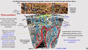
This figure shows the interpretation of section D-D’ (top) which corresponds to the top 800 km depth of section M-N across Southern Africa. The structures and domains correlate excellently in the two sections. This gives us confidence that the lower 2,000 km of the section M-N is revealing true structural geology. The plume (dark area outlined in red) starts at the Core Mantle Boundary right where the vertical structures under the east and west of Africa converge at the core. Is this where the fluids that form the ore-bodies at the surface originate?
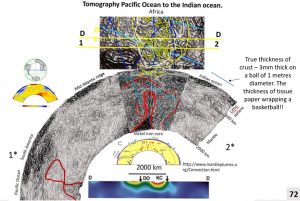
We will now look at seismic tomography from the Indian Ocean, on the right, over Africa, across the Atlantic Ocean and across South America to the Pacific Ocean – a good broad look to define the overall structural geology.
Being such a broad section the seismic tomography data is relatively course and so it will be interesting to see if the structural geology correlates with the structure of geology in the more detailed sections. Would this be the world’s largest structural geology plan??
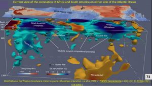
This is the view from 2018 of the best attempt at getting a three-dimensional diagram for the area of Africa to South America (Hu et al. 2018). It has a lot of objects which appear three-dimensional but as we have seen in the previous section under Africa the plume as shown, cannot be a three-dimensional object.
This object is an area that has similar values of heat and wetness that cause the variation in the speed of seismic waves through this area.
We could also see in the plans and sections down to 400 km that the original Hadean ring structures are unaffected in shape by this heat coming up from below.
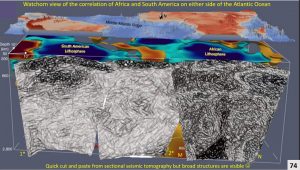
This is a quick cut and paste of the more detailed section under Africa (section M-N) with less detailed sections under the Pacific and South American lithosphere from section 1*-2*).
The brittle structures under Africa continue across the Atlantic with maybe a small section under the mid-Atlantic Ridge with less brittle structures but once again in the South American lithosphere there are strong vertical structures again.
Flat east dipping structures that are seen in the detailed D-D’ and M-N sections also continue right across. Ones that originate under South America intersect the core under Africa.
This is all absolutely new structural geology information to be analysed but may relate to spiral structures outlined in O’Driscoll in 1980.
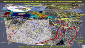
This isometric diagram shows the lithosphere down to the Core Mantle Boundary, Africa’s surface is Landsat, Africa’s lithosphere at 400 km depth, suspected movement of the mid-Atlantic Ridge and South American lithosphere at 200 km depth.
Large ring structures at 400 km depth off the West Coast of Africa correlate with the large ring structure on the east coast of South America. The hypothesis that South Africa and South America drifted apart after Gondwana 100 million years ago is most likely correct but the distance they have moved apart is possibly only hundreds of kilometres east-west movement instead of thousands.
This detailed structural geology to the Core Mantle Boundary should make us revise our hypotheses of the conditions under which the Earth formed and how much (or how little) it is changed it has changed compared to our current hypotheses.
9. Africa Continent Evolution – Watchorn working hypothesis versus current recognised hypothesis.
This paper is only an introduction to Africa continent evolution and is based on research of the sub-African lithosphere from the surface to 2,900 km depth.
This is the first research to use ultra-detailed seismic tomography. This great increase in detail enables lithospheric geological structures to be seen in plan and section eventually enabling a true 3 D model to be made of the continent. It has also enabled the lithosphere/crust timing relationships to be observed.
Thus, this research is able to give a much more accurate model of the continent’s evolution than the current hypotheses based on very coarse lithospheric data.
It also enables detailed observation of the location and possible formation of Africa’s mineral deposits and their relationship to the underlying structures in the lithosphere.
This data has led to my working hypothesis that;
- The presence of a world wide ocean suggests early Earth was cool.
- The lithosphere is thick (>800 km) and continuous under all the continents studied so far Australia, Antarctica, North and South America, China, Russia and now Africa. It is over 4 billion years old at the Moho as the oldest rocks in the crust are this age (Nutman et al, 2007)
- The detail now seen of the lithosphere/crust timing relationships suggests that the lithosphere developed from 4.5 billion years ago till about 3.8 billion years ago to a depth of at least 800 km.
- The Late Heavy Bombardment (LHB Taylor Redd 2017) of 4.1 -v 3.8 billion years ago most likely caused the majority of the original >800 km thickness of the lithosphere.
- The lithosphere remained intact up until the start of Plate Tectonics which probably commenced about 2.7 billion years ago (McCall 2010) triggering the start of the world’s biggest mineralising event.
- Original deep lithosphere was the basis for an original worldwide mega-continent as is postulated for the other inner planets – Mercury, Venus, Moon and Mars (University of Maryland 2020).
- Earth is different only in that its >800 km deep mega-continent has been progressively broken up by Plate Tectonics which most likely only commenced properly about 2.7 billion years ago (McGall 2010).
The current official working hypothesis is that;
- The Hadean Earth was hot and mobile and most of the solid lithosphere had been recycled by 4 billion years ago (Choi 2012, Chowdhury et al. 2017).
- There were only small seed continents at the start of Plate Tectonics, of which Vaalbara (Congo Craton) in Africa is one of the oldest (Linol et al, 2014).
- These seed continents were gradually enlarged as they collided and accreted over the last 4 billion years (Algol 2018).
No doubt both systems are in operation. However, the continuous thick lithosphere, most of which can only have been formed by the Late Heavy Bombardment impact structures, still remains intact under all the remaining continents which is a big departure from the starting conditions of the current Plate Tectonic hypothesis.
These lithospheric, giant impact structures (up to 5,000 km diameter), are overlapping and overlying each other and generally have not been broken up and segmented. This strongly suggests that the primary modus operandi of Plate Tectonics started as a worldwide 800 km thick mega-continent, which is gradually breaking up.
The next section concludes the webinar on Africa transcript.
Share this ground-breaking geological research with your colleagues.

