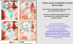
We’ll now look at the seismic tomography at of 300 km depth. We will use this less detailed dataset.
The plan has been enhanced mainly to show rings. One thing I noticed was that Africa’s coastline follows the rings suggesting uplift or intrusions around the ring structures. This is the same in many continents. In Australia the NW coast follows ring structures and the Great Australian Bite follows the interior of a large ring structure.
Overlaying the mines on the tomography plan it can be seen that the mines follow the ring structures more closely than the levels above.
The mines are superimposed over the tomographic plan at 300 km depth. We can once again see the gold mines lying generally in the dark heavily structured areas and the diamond mines are on the light-coloured areas. There is very good correlation with the ring and linear structures. The mines correlate more closely with the structures at 300 km level than at shallow levels or the geology at the surface.
It is suggested that we are closer to the area of greatest leaching and replacement of the lithosphere by the mantle hot fluids. These fluids are being forced vertically through whatever structures are available to the surface. They scavenge metals on the way up and deposit them near the surface as the temperature and pressure decreases.
In the figure we can see that the diamond mines in the Copper Belt are bracketed by the East West fuzzy zone and the ENE zone. This is confirmation of what we saw in the South African Diamond Fields where the diamond fields were also bracketed by these linears.
For the first time the mines are seen not only in the annulus of the small rings like the Congo Craton but also in the large 5,000 km ring centred in North Namibia suggesting a correlation with these giant structures at depth.
And what is that double arc of a 5,000 km concentric ring doing out where the Mid-Atlantic ridge is supposed to lie?? Is there something going on here that doesn’t tally with the currently accepted recent separation of Africa and South America? Is the mid-Atlantic ridge only a shallow feature?
This figure shows the seismic tomography at 300 km depth and cross section B across from West Africa through Central Sahara to Arabia. The linear structures and the circular structures show up clearly on both plan and section. They correlate extremely well.
West African Craton ring structure lies directly above the bowl structure (yellow dashed arc) in the section as does the central Sahara Craton on. These bowl shaped structures most likely formed during the Late Heavy Bombardment from 4.1 – 3.8 billion years ago as this is the only recorded event that formed circular ring and bowl structures this big.
The East African Rift bottoms out at about this level but it can still be seen as vertical lines through to the base of the section at 800 km depth.
The bowl-shaped structures continue under the East African Rift through to the Arabian Nubian shield. This strongly suggests that the African continent was one huge land mass at the time these bowl-shaped structures were formed. The double fault that we saw up on section at 60 km depth is still correlating with the same linear at 300 km depth.
If we travel 5,000 km south to the Congo Craton/Copper Belt and compare section D it is exactly the same structural geology as section D. The bowl structures continue right across the continent into the Atlantic Ocean and the Indian Ocean suggesting the continent was one huge landmass at the time the bowl structures formed here also. The remnants of the east African rift and the African Valley rift can be seen as strong vertical structures in the east.
The Copper Belt mines can be seen to lie above vertical structures extending the full 800 km depth on the section. The current theory of Plate Tectonics suggests that the only Congo Craton was the first plate in Plate Tectonics at about 3.8 billion years old.
One can be confident that these two sections show that the African continent was one landmass greater than 3.8 billion years ago and that the timing and mechanics of Plate tectonics now needs major revision.
In the next section we will be looking at the Carlin/Battle mountain/Butte/Bingham Canyon area in Western USA and comparing exploration targeting in this fantastically mineralised area with Africa and the Australian Yilgarn mineral mineral fields.
If you like this and find it useful (or even if you don’t) SHARE IT with your colleagues and drop me a note in the comments below……..
