Figure 17. Enhanced gravity image of North America depicting the density of earth as topography showing linear and ring structures.

North America. Part 3. EagleEye gravity enhancement showing giant rings, linears and their correlation with mineralisation.

North America. Gravity enhancement showing giant rings, linears and their correlation with mineralisation.

Like it? Share it!
Figure 8. North America Landsat ultra-enhanced image showing large rings and their relationship to mining fields.

North America AusIMM Webinar. Part 2. Landsat EagleEye ultra-detailed research of structural geology correlation with mineralisation.

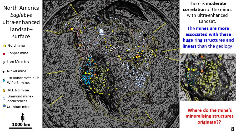
North America. Landsat EagleEye ultra detailed research of structural geology correlation with mineralisation. The mines are plotted onto the Landsat image. Find out, in this series of posts, how to do exploration targeting from the continental scale right down to the mine scale – all from continental scale original data!

Like it? Share it!
AirGeoX EagleEye comparison of 10m spaced Magnetics

Comparison of AirGeoX’s filtering method and Watchorn EagleEye method of obtaining structural geology from Magnetic images.

EagleEye structural geology ultra-enhancement of magnetics image from AirGeoX’s LinkedIn post. There is a comparison between the filter method and my structural recognition program EagleEye method of a 10m spacing magnetics survey

Like it? Share it!