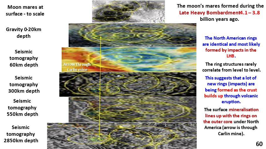
Figure 60. Stacked sections of North America from outer core to surface with inset of Lunar Mares for comparison.
Read the annotations on the above figure before you start the text below.
This plan summarises the ring structures under North America from the surface down to the core.
The yellow arrow trends through the Carlin deposit in all sections.
The ring structures are smaller at the surface but still very large. There is a maximum diameter at about 500 km depth of 5,000 km. The ring structures rarely correlate from level to level, except for the largest, which suggests that they are formed by multiple impacts and lava flows that build up over time after each impact.

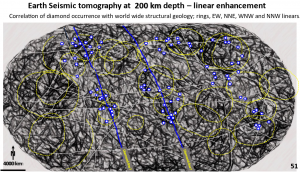
This 200 km depth seismic tomography plan (figure 51 https://www.geotreks.com.au/work/giant-ring-structures/worldwide-structural-geology-at-200-km-depth/) shows that these ring structures are present over the whole surface of the earth.
My research is mainly for the economic benefit of exploration targeting. Thus the only reason I have studied this specific North American area is because it is a continental landmass which has mines on it.
Current geological wisdom separates the oceanic and continental areas based on the fact that one is covered by ocean and the other is not 🙂 .
At 200 km depth there is no structural geological difference seen on this plan. Thus the oceanic ‘plates’ and the continental plates have the same geology under the very thin surface crust – however, the crust is different.
The observation that there is no change in the density, morphology or size of the rings from the surface to 550 km depths suggests that there is no mobile mantle.
This is in such complete contradiction to the current Plate Tectonics Theory that some skeptical readers have decided to not believe that any of my structures are real.
To those skeptical geoscientists I say, if the known surface structures that I clearly outline, such as the ones below, are shown to be real, then there is no reason to disbelieve the buried ones just because they cannot be seen and that you can not produce them yourselves yet.
As Molly Meldrum (Australian joke 🙂 ) said, ‘do yourselves a favour’ and examine the posts below and see what you then believe!
Examples of ultra-enhancement of verifiable, well researched, structures using EagleEye enhancement.
Impacts
Vredefort impact structure https://www.geotreks.com.au/work/giant-ring-structures/vredefort-impact-crater-africa-eagleeye-enhancement-seismic-tomography-60-km-depth/,
Chicxulub impact structure https://www.geotreks.com.au/work/giant-ring-structures/south-america-seismic-tomography-structural-geology-chicxulub-27-km-depth/ ,
Araguainha impact structure https://www.geotreks.com.au/work/giant-ring-structures/south-america-landsat-implications-for-plate-tectonics-continent-formation-and-mineralisation/, Figure 6.
Other conclusively definable structures are clearly shown in 3D for the first time such as the;
African rift system in plan and down to 450 km depth in 5 sections, https://www.geotreks.com.au/work/giant-ring-structures/african-landsat-and-tomographic-section-correlation/ ,
Mid Atlantic Ridge down to the outer core in section,
South Atlantic, https://www.geotreks.com.au/work/giant-ring-structures/south-america-africa-seismic-tomography-section-15s-through-5n/
North Atlantic, – next post
The Pacific plate subduction under the west coast of North and South America in section,
North America, https://www.geotreks.com.au/work/giant-ring-structures/north-america-550-km-depth-seismic-tomography-and-cross-section-36n/
The Norseman Wiluna Gold bearing antiform in plan and section, https://www.geotreks.com.au/work/giant-ring-structures/yilgarn-craton-tomography/ and https://www.geotreks.com.au/work/giant-ring-structures/yilgarn-geology-tomography/,
The structure of the North Sea and American oil and gas fields in plan.
North Sea, future post.
Stawell goldmi9ne in Victoria, Australia, in plan and section I verified and outlined the mine scale structures, using EagleEye, which I had postulated in my MSc thesis and were later found by drilling and mining.
Stawell cross section, https://www.geotreks.com.au/work/projects-studies/stawell-gold-mining-area-mine-scale-exploration-targeting-using-eagleeye-enhancement-of-magnetics-in-plan-and-300-magdala-cross-section/ .
There are many more verifiable examples I could show but we’ll leave it there! If you want more proof you only have to ask!
I’ll produce a post soon with all these examples as images in the one post.
Sooo …. maybe in the light of this totally new, much more detailed, structural geology evidence we have a lot of re-thinking to do on the structure and evolution of Earth!!
Happy re-thinking for the open minded, innovative among you, and for the rest – tortured re-thinking 🙂 and perhaps some homework!
Most importantly explorationists, use the exploration targeting plans to do just that, as if the structures and theory are real the early, most savvy bird gets all the good projects!
Cheers
Bob Watchorn

