
This is the deepest for which I have good seismic tomographic data on Africa. The fast cratonic areas are smaller and the mantle has reached to this level of replacing the cratonic material.
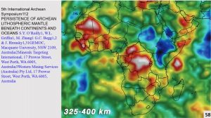
The super-continent of Africa extends nearly to the centre of the Atlantic Ocean, across to Iran and east and south of Madagascar. The East Africa Rift is amalgamating into a circular low which is surrounded by a ring of cratonic material around the north, west and south sides.
This is similar to the Central Australian Cratonic low which has filled with later surface material and passively intruded by mantle material from below (Watchorn 2019. AC # 2, figure 4). In both cases these are probably the largest original impacts which started forming the Lithosphere >4.1 billion years ago.
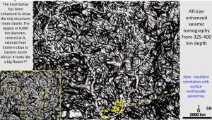
This plan shows the ultra-detailed structural geology obtained from the seismic tomography at 400 km depth. This plan was enhanced mainly to show linears and the NE linears show up best. Numerous large ring structures are also visible, especially the Congo craton area.
The left-hand inset has been enhanced to show the ring structures more clearly. The largest at 8,000 km diameter, centred at A in the centre of the East Africa Rift, extends from Eastern Libya to 1000 km east of South Africa! It’s shaped like a big rosette?
The down-arcs associated with this huge ring structure confirm it is an impact structure acting from above, not a huge plume coming up from below.
It is instructive that the surface seismic epicentre plan correlates best with this level suggesting that the tectonic movement causing the seismic activity at the surface may have originated from this depth, or greater.
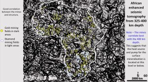
This plan shows the surface mines superimposed on the structural geology at 400 km depth. Even at this broad scale the metal mines are seen to be located almost exclusively on the dark areas on the ring boundaries, arcs and portions of rings and cluster where these cross the linears. Even more conspicuously the diamond mines still lie on the white cratonic areas.
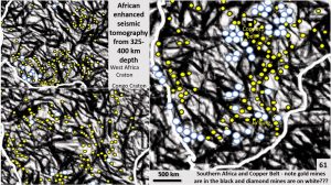
At this closer scale the metal mines are located almost exclusively on the dark areas on the ring boundaries, arcs and portions of rings and cluster where these cross the linears. Even more conspicuously the diamond mines still lie on the white cratonic areas.
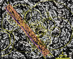
This figure shows section E-E’ which is 9,000 km long and starts in the Atlantic Ocean off Mauritania and finishes in the Southern Ocean off South Africa. The top of the section is cut off at 400 km depth.
It has very similar structural geology to the tomographic sections B and D across Africa previously examined. There is no sign that Africa formed as a series of accretions. The 660 kilometre depth seismic reflection zone (blue line) is continuous and unbroken along its whole length as are the bowl-shaped structures (yellow down-arcs) located under the circular structures at all depths.
The ring structures and the bowl-shaped structures correspond with each other the best of any depth so far. The very visible bowl structures relate to the rings, even the big 8,000 km diameter ring has a large flat bowl structure associated with it.
All the structures seen on this section at this 400 km deep level are brittle. Also, they have not been moved or distorted to any extent since they were formed. The only force large enough to have formed the structures is the Late Heavy Bombardment which operated from 4.1 – 3.8 billion years ago.
The only break in the section E is where the southern extension of the East Africa Rift cuts through the section. The character of the geology is brittle and changes from layered with bowl structures, to vertical structures and massive cracking down to the 800 km depth of the section.
So once again this is evidence that Africa formed as part of a super-continent in the Hadean eon (> 4 By) and has not been broken up since. This poses great challenges for the current Plate Tectonics concepts and mechanism.
Of particular note is how the diamond mines now closely follow rings in the white cratonic areas. This is yet another targeting criterion.
Conclusions for this section.
The mines lie closer to the structures at 400 km depth than they do at the surface. This suggests that the mines are related to structures at this depth – or deeper.
The metal mines lie in the structurally disrupted areas and the diamond mines in the less disrupted cratonic ares at 400 km depth.
Both these above mine/structure observation aid in exploration targeting for lookalike areas for new mineral fields.
There is strong evidence that Africa formed as part of a super-continent in the Hadean eon (> 4 By) and has not been broken up since. This poses great challenges for the current Plate Tectonics concepts and mechanism.