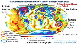
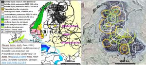
Fennoscandia and Russia seismic tomography showing surface geology lithosphere comparison.
This pilot study research examines the structural geology of Fennoscandia – Western Russia by comparing the surface geology and Landsat with the plan seismic tomography from 100 through 270 km depth.
Current public seismic tomography research only defines structures of > 50 – 100 km smallest dimension. The paucity in references to research showing detailed seismic tomography of FennoScandia/Russian craton structural geology is because there are no published papers covering the topic in the available databases searched.
The FennoScandia/Russian Craton occupies the core of the Eurasian continent. The underlying cratonic Lithosphere extends unbroken from Finland to south western Russia in the Caspian Sea area. This area has dimensions of 3000 km NS and 1500 km EW.
The geochronology of the area ranges from 3.5 Ga in North Eastern Scandinavia to 250 my in the Caledonian orogenic belt in Norway. The majority of Russia is Palaeozoic. The deep cratonic roots appear to underlie this varying surface geochronology.
The giant ring structure structural geology and morphology suggest they were formed by impact from above. Their relatively circular nature suggests that have remained undeformed since the Hadean.
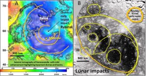
Inset A. The blue areas represent Fennoscandia Russia’s underlying Archaean cratons at 270 km depth.there is a lighter blue, shallower lithosphere basement in the centre of the Rybinsk giant ring structure (orange) indicating uplift (or replacement by mantle) of approximately 100 km. This is similar to the elevated centres of the largest impact centres in Australia, North America and China.The deep cratonic roots appear to underlie the varying surface geochronology.
The surface topography at the Rybinsk centre forms the large Rybinskoe Lake which is deeper than the surrounding areas. Theoretically, the more fractured centre should be preferentially raised from isostatic uplift. However, the surface is most likely lower because of continual glaciation. This would suggest that this central impact area is more fractured than the surrounding areas. This is similar to the surface expression of the largest ring structures in Australia, North America and China.
Inset B. Lunar Mares are formed by volcanism following the LHB. (Hiesinger et al. 2000). They are of a similar size and density to the Fennoscandia Russia giant ring structures. Did they have the same formation and how did they survive on the mobile earth.
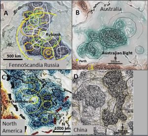
The ring structures (impacts) in the lithosphere areas researched so far are very similar in size and morphology.
Fennoscandia and Russia seismic tomography showing comparison with Australia, North America and China lithospheres.
These structures have the appearance of half of 3000 km diameter donuts. In Fennoscandia Russia, Australia and North America it is suggested the donut has split in half.
The other half of the Fennoscandia Russia donut would be the Siberia craton in eastern Russia.
The other half of Australia would be Antarctica with the centre in the Great Australian Bight (Watchorn; Focus on Innovation 2019 https://www.geotreks.com.au/work/giant-ring-structures/ausimm-innovation/ ). This will be investigated in my next paper.
The centre of the North American donut is the Saskatchewan ring structure. The other half of the North American donut lies in the Cordillera west of the Rocky Mountains and is being subsumed by the advancing Pacific plate. However, I believe large sections remain and large ring structures still exist – complete with North America’s largest gold systems (see figures 1 and 2 and Watchorn NA #1 2019; https://www.geotreks.com.au/work/giant-ring-structures/north-america/geology-north-america-300-km-depth-seismic-tomography/ ).
Formation and survival of the Hadean giant ring structures and cratons.
There is a strong belief among geoscientists that the early crust was too thin and plastic for impacts to form.
What was the early earth crust really like? From my seismic tomographic research it seems it was much like the crust today but thinner and with a higher temperature gradient.
I have been queried as to whether it was too soft to form permanent impact structures especially ones 300 km deep. However, a thinner crust would still react to impacts. The impacts also help solidify the crust through accelerated heat loss.
The oldest earth rocks (which formed before and during the Late Heavy Bombardment are described on website http://www.oldest.org/geography/rocks/
—- The Jack Hills Zircon is believed to be the oldest geological material ever found on Earth, dating back to about 4.375 billion years, give or take 6 million years (Wilde et al 2001).
—- Scientists published their findings in February 2014 in the journal of Natural Geoscience after analysing single atoms of lead in a zircon crystal from Australia’s Jack Hill range. The trace elements found in the zircons suggest they came from water-rich, granite-like rocks such as granodiorite or tonalite. According to researchers, this information shows that “the earliest Earth was more like the Earth we know today”, which contrasts with earlier theories that said Earth was initially inhospitable —-.
—- Confirmation of the zircon age holds enormous implications for models of early Earth. Trace elements in the oldest zircons from Australia’s Jack Hills range suggest they came from water-rich, granite-like rocks such as granodiorite or tonalite, other studies have reported. That means Earth cooled quickly enough for surface water and continental-type rocks just 100 million years after the moon impact, the massive collision that formed the Earth-moon system. —–
—- Using zircon oxygen isotopes, researchers previously discovered that liquid water covered parts of our planet some 4.3 billion years ago, suggesting the surface cooled just a few hundred million years after our planet’s formation. And just last year, researchers found what they believe might be hints of early life in the form of carbon-rich inclusions in 4.1-billion-year-old zircons —– (Wei Haas 2014)
— In 2001, geologists found the oldest known rocks on Earth, the Nuvvuagittuq greenstone belt, on the coast of the Hudson Bay in northern Quebec (Thompson 2008). Geologists dated the oldest parts of the rockbed to about 4.28 billion years ago, using ancient volcanic deposits, which they call “faux amphibolite”. Since the rocks’ discovery, their age has been contested as different research has turned up different dates ranging between 3.7 billion – 4.37 billion years. A report published in March 2017 provides evidence that fossils of microorganisms have been found in the Nuvvuagittuq rocks, which would be the oldest trace of life yet discovered on Earth. —
—- The Isua Greenstone Belt is one of the oldest rock formations on Earth, aged between 3.7 – 3.8 billion years. Recent research uncovered the fossilized remains of cone-shape stromalites, which are layered mounds of sediment and carbonates that build up around colonies of microbes that grow on the floor of shallow seas or lakes http://www.oldest.org/geography/rocks/.
If the earth’s surface contained oceans and was cool enough for life to form then it was also cool enough and hard enough for impact structures to form.
It is also another common belief among geoscientists that early impacts were quickly destroyed by early Earth’s supposedly mobile crust and by erosion?
Bercovici, Tackley and Ricard in 2015 argued that there is ample evidence that the Earth only underwent a transition to more global plate tectonics by 3 – 2.7 Ga. Stern 2015, argues that true Plate Tectonics didn’t commence until the Neoproterozoic (1 Ga to 541 million years ago). Thus, there was no Plate Tectonics earthscale force to break up these early cratons.
Either way, plate tectonics probably only commenced on a large-scale after 3 – 2.7 Ga. This postdates the time of the last researched ring structures in the Yilgarn craton, Western Australia and is post craton formation. This age (3 – 2.6 Ga) correlates with the greatest worldwide concentration of mineralisation (Ho, Groves and Bennett1990, Bateman et al 2001, Bateman 2007). This mineralisation may have occurred because of the intense re-activation by Plate Tectonics of pre-existing structures, including the giant ring structures.
What is the reason the oldest original Earth cratons still exist over large areas?
There was probably up to 300 km thickness of heavier mafic rocks extruded during the intense Late Heavy Bombardment (LHB) period (Jones 2005) which extended over 300 million years from > 4.1 – 3.8 Ga (Alt, Sears and Hyndman, 1988, Hiesinger et al, 2000).
Volcanism, vertical tectonics, Rayleigh–Taylor flow (Wyche, Nelson, and Riganti, 2004) and subsequent erosion gave great buoyancy to these cratons. It is suggested that most of the largest LHB impact created cratons still exist because of this great buoyancy. Their rigidity would have been enhanced by the huge thickness of sandwiched lavas and sedimentary rocks (similar to sandwich construction panels).
Using the analogy with Earth’s twin planet, Venus, Hansen 2016 suggests that during the Hadean eon (4.5 – 3.8 Ga) the numerous impacts caused large scale volcanism which extruded heavier mafic material over the craton areas pushing the increasingly felsic roots deeper and providing buoyancy and forming the Venus, and Earth, cratons. On Earth, because of this great buoyancy, they have floated above the plate tectonic subductions and survived.
In these other continents the sections show that the ring structures terminate below the Moho but are seen as rings and linears in the crust by transferrence as Trans-Lithosheric structures. The main rings are seen in the crust in structurally enhanced Landsat.
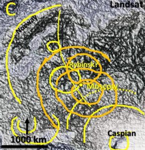
Fennoscandia and Russia seismic tomography correlation with Landsat
The linear and arcuate interpretations follow structures consisting of darker areas which may be rivers/vegetation which follow fault zones. The rings follow darker structures which cut across these linear structures suggesting constant reactivation of underlying ring structures and not the formation of new surface structures.
Of interest is the structure (topography) of the sea floor (top right) which is based on apparently poor undersea topography in the Landsat image. This is checked below against the detailed topography for verification of data purposes.
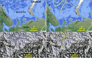
The arcuate structures in the enhanced Landsat match those in the raw Landsat. When the oceanic Landsat is viewed closely the Relative Levels of the seafloor topography is revealed. It is very detailed! The detailed data is all there even in a fuzzy very pixelated image. I presume this is also the case for the land area and is why such detailed enhancement is possible.
In Australia the source of fluids, the fluid pathway and the genetic source of mineralisation is revealed. Will this be the case in Fennoscandia Russia? What are the implications for further discoveries in this largely covered area?
It is expected that the structures outlined in the FennoScandia Russian Craton’s seismic tomography relate to real structures. Cross checking of structures will be doneby the Author but this detailed verification of structures will be no doubt completed by the FennoScandia/Russian geoscientists most interested in deepening their knowledge of their continent’s geology and finding the next big new mineral or oil and gas field!
Share this post!!!
If you found this precis informative then the main paper will be of great interest. Click the URL below to access the main paper ——
| Seismic tomography geology and Landsat of Fennoscandia Western Russia.pdf | 2 MB |

