
O’Driscoll GRS research on; dimensions, genesis, age and targeting potential.
O’Driscoll giant ring structure (GRS) is named to honour Tim O’Driscoll for his ground breaking, paradigm changing – still controversial – research.
O’Driscoll GRS location and history;
O’Driscoll GRS centre is near the Davyhurst mining centre at coordinates 30˚02’S and 120˚38’E. It is 500 km in diameter to the outer ring. Tim O’Driscoll, while working for Western Mining Corporation (WMC), had evaluated the Australian giant ring structures (GRS) by the end of the 1970s. Tim considered these were impact structures similar to those on the moon. copies of some of the plans used for his hardcopy work are available at; Media file of O’Driscoll maps. Data.Gov.au https://data.gov.au/dataset/odriscoll-lineament-maps-of-australia/resource/89594ede-ecc1-44ca-b3cf-2e093b3b7f65.
Controversy;
It is interesting and a little disturbing that, despite their clarity in many datasets, that NONE of these ring structures have been seriously researched since Tim’s discovery of them in the 1970s, except by the author. This is probably a measure of the unwarranted controversy they still generate? This controversy is to the detriment of good geological research but the upside is that it means good orebodies remain to be discovered if these rings are used as exploration tools!
This lack of interest may be because of the paucity of shock textured rocks on the Yilgarn surface indicating impacts. Apart from those associated with the small late Yarrabubba impact the only reported rocks with impact related shock textures are those in diamond drill hole ELV 071 which was drilled into the strong Leonora ring of the Watchorn GRS, suggesting it is an impact structure.
Therefore, the Yilgarn Craton has been the focus for extensive geological research but the current underlying research assumptions do not cover all geological concepts. A literature review suggests there is no universally accepted hypothesis for the formation of the Yilgarn Craton and its mineralization. These literature studies show, by omission, that multiple Archaean giant ring structures (>2.7 Ga age and >200 km diameter) are not even recognised and thus are considered non-essential to the Yilgarn Craton development or its mineralization??
Back to basics.
What ring creating processes operated 4.3 – 2.5 Ga ago prior to plate tectonics? The older (>3.2 Ga) cratons formed with thinner crust, hotter earth, worldwide ocean and lack of plate tectonics. Maybe giant impacts should be included as a complementary (or perhaps underlying) mechanism of Archaean crust and mineralisation formation?
O’Driscoll GRS Geology.
There is a relationship between O’Driscoll GRS and the Yilgarn geology. The regional geology is partially disrupted in the path of the O’Driscoll rings and some of the greenstone belts appear to terminate on, or follow, the outer ring path.
The geographical continuity of O’Driscoll GRS suggests that the whole eastern Yilgarn Craton is underlain by greater than 3 Ga lower crust.
Geologically, all the researched GRS cross the terrane boundaries and thus present as younger structures. It is suggested they are old, deeply buried, constantly re-activated and intruded structures. This suggests an undeformed underlying older Greater Yilgarn Cratonic plate at the time of the GRS formation. If, as seems probable, they formed during the late Heavy Bombardment (LHB) then the age of this underlying plate is at least 3.8 Ga in age.
This research (including Leinster-Windimurra seismic section 10 GA YU 02 and Leonora Lake Yeo 01 AGS NY 01 seismic section) suggests that O’Driscoll formed earlier than the gneisses and was active through all other intrusive and deformation events, by re-activation of the original ring structure as palimpsests or Trans-Lithospherical structures.
O’Driscoll GRS topography.
In the topography the O’Driscoll rings can be seen clearly in the NW and NE quadrants where the palaeochannels follow the Permian glaciation over-deepened zones. This reasonably regular circular pattern of ice erosion is more continuous and deeper than in Watchorn, Malgar and Cauden GRSs. This suggests that the O’Driscoll giant ring structure formed later, nearer the cessation of Yilgarn craton development and has undergone less homogenising metamorphic activity since GRS formation. This fracturing and movement around the rings may be continuing which suggests subvertical, very deep circular structures are present. The above suggest that the GRS structures have steeper, deeper, more extensive, stronger fracturing than those accompanying the other early Yilgarn craton processes.
O’Driscoll GRS radiometrics.
In radiometrics the O’Driscoll ring structure is very obvious. O’Driscoll GRS has bright blueish/purple (uranium/potassium) arcs following the palaeochannels. However, the radiometrics rings also cross over elevated terrain and are more regular and wider than the palaeochannels. They probably represent the original ring structures the palaeochannels later follow. The prevalence of these fairly narrow bands of high potassium/uranium radiometrics may indicate a connection with gold mineralisation (Ho et al 1990) which has elevated potassium metasomatism.
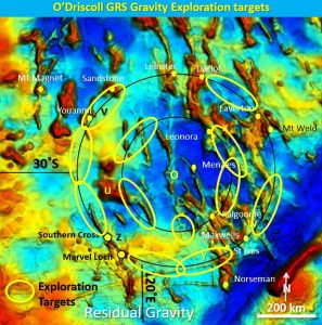
O’Driscoll gravity.
In gravity there is a correlation of the later mafic intrusives with O’Driscoll GRS. The greatest volume of intrusives in the Eastern Goldfields Superterrane lie between the two O’Driscoll rings. There is a greater intrusion of mafic rocks in the older Youanmi terrane along the outer ring, between the rings at Mt Manning and the Southern Cross greenstone belt follows the outer ring. The majority of the large mines lie in these mafics and the largest of these lie on the two rings.
O’Driscoll Gold mineralisation.
A high proportion of the largest gold mines are associated with O’Driscoll GRS. This suggests a spatial relationship to the widespread main gold mineralisation event that occurred near the finalisation of Yilgarn cratonisation.
Gold mineralisation targeting.
The 30˚S seismic tomography section suggests these giant ring (phi Ø) structures extend to at least 250 km depth as steep arcuate and bowl structures (Watchorn, 2018. https://www.geotreks.com.au/work/giant-ring-structures/watchorn-grs-craton-tomography/. These are the prime structures up which stress is relieved and up which mineralising intrusive rocks and fluids will travel.
The first pass exploration target areas are located where the main rings intersect the greenstones and NNW, NW and NNE structures. Many of these target areas have no mines in them! Many have not been explored because they are covered by surficial rocks and detritus. The longevity of the underlying structures may mean underlying older Archaean deposits are remobilised and become targets even in less than optimal host rocks at the surface.
If you find the paper useful please follow this website and share with your colleagues!
For the full paper go to the file below —–
| YO #1 ODriscoll GRS.pdf | 2 MB |